|
||

|

|
|

|
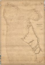
A detailed map showing several harbors in the Bahamas, first published by the British Admiralty in 1898. Seven separate maps show different anchorages, covering most of the islands in the northwesternmost part of the Great Bahama Bank. The charts show extensive navigational information, including soundings, tidal information, reef channels, rip currents, and more.
The islands pictured are all part of the Bimini district of the Bahamas, including the Bimini islands, the Cat Cays, Great Isaac Cay, and various other small islands. The region is only sixty miles offshore of Miami, due east.
Partly due to the district's proximity to the US, Bimini has had an extensive history. Juan Ponce de Leon believed the Fountain of Youth to be at this location, giving the island its name. Bimini played a prominent role during prohibition as an important supply point during rum-running, being the closest Caribbean harbors to the mainland US. Ernest Hemingway also spent two years of his life in Bimini.
The British Admiralty published some of the best available sea charts into the modern era. This can be seen in the extensive soundings and other notes that have been made on the present map. Further information such as lighthouse signals is detailed. Inland areas, including the occasional building, are equally well documented. Some notes are made on topography, and all major roads and buildings are annotated. Manuscript notations provide some additional navigational information.
In all, this is a good quality map of the westernmost Bahamas, remarkable for its visual simplicity while conveying extensive information.
The British Admiralty has produced nautical charts since 1795 under the auspices of the United Kingdom Hydrographic Office (HO). Its main task was to provide the Royal Navy with navigational products and service, but since 1821 it has also sold charts to the public.
In 1795, King George III appointed Alexander Dalrymple, a pedantic geographer, to consolidate, catalogue, and improve the Royal Navy’s charts. He produced the first chart as the Hydrographer to the Admiralty in 1802. Dalrymple, known for his sticky personality, served until his death in 1808, when he was succeeded by Captain Thomas Hurd. The HO has been run by naval officers ever since.
Hurd professionalized the office and increased its efficiency. He was succeeded by the Arctic explorer Captain William Parry in 1823. By 1825, the HO was offering over seven hundred charts and views for sale. Under Parry, the HO also began to participate in exploratory expeditions. The first was a joint French-Spanish-British trip to the South Atlantic, a voyage organized in part by the Royal Society of London.
In 1829, Rear-Admiral Sir Francis Beaufort was appointed Hydrographer Royal. Under his management, the HO introduced the wind force scale named for him, as well as began issuing official tide tables (1833). It was under Beaufort that HMS Beagle completed several surveying missions, including its most famous voyage commanded by Captain FitzRoy with Charles Darwin onboard. When Beaufort retired in 1855, the HO had nearly two thousand charts in its catalog.
Later in the nineteenth century, the HO supported the Challenger expedition, which is credited with helping to found the discipline of oceanography. The HO participated in the International Meridian Conference which decided on the Greenwich Meridian as the Prime Meridian. Regulation and standardization of oceanic and navigational measures continued into the twentieth century, with the HO participating at the first International Hydrographic Organization meeting in 1921.
During World War II, the HO chart making facility moved to Taunton, the first purpose-built building it ever inhabited. In 1953, the first purpose-built survey ship went to sea, the HMS Vidal. Today, there is an entire class of survey vessels that make up the Royal Navy’s Hydrographic Squadron. The HO began to computerize their charts in the late 1960s and early 1970s. In 1968, the compilation staff also came to Taunton, and the HO continues to work from there today.
![Cuba, Jamaica and Porto Rico [Cayman Islands]](https://storage.googleapis.com/raremaps/img/small/78708.jpg)