


|
||

|

|
|

|
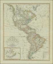
A Storied Rarity -- Zilletti map of New World.
Nice example of Giordano Ziletti's rare map of America, published in Venice in 1557.
Ziletti's map is drawn from Diogo Ribiero's monumental Carta Universal . . . world map of 1529, drawn for King Carlos V of Spain. Ribiero would later become the Piloto Major (replacing Sebastian Cabot), Royal Cosmographer and the maker of the maps which Ferdinand Magellan took with him on his voyage across the Pacific Ocean. At the time of its creation, Ribiero had access to the full archive of Spanish knowledge of the Americas, including the Real Patron.
Ziletti's map is an enlargement (more than double the size) of Jean Bellere's of the New World (1554). It includes important from the expeditions of Lucas Vasqueze de Ayllon, Estêvão Gomes and João Álvares Fagundes, each of which was reported in Ribiero's map of 1529. Among early maps of the whole of America, only Giovanni Ramusio's La carta universale della terra firma . . . of 1534 and Pedro de Medina's Nuevo Mundo of 1545 pre-date Bellere's map. The earlier pair include very few place names, while Bellere's map includes dozens of names.
The map incorporates the double-headed eagle, symbol of Leon & Castille, confirming its Spanish origin.
For many years, it was believed that Ziletti's map was actually published in England in 1555, which would have made it the first map of America published in England and the earliest regional map printed in England. In his original entry for this map, Burden noted:
This excessively rare map is identified as belonging to Richard Eden's The Decades of the World, however, there is no proof of this. All of the recorded examples are loose with the exception of the New York Public Library copy where it has been added to the book at a later date. It was the first collection of voyages published in the English language. The map is derived from that of Jean Bellere the previous year. It is one of the earliest [maps] printed in England, being pre-dated only by the yet to be discovered state of Thomas Gemini's map of Spain, only known by a 1555 example. The larger size enables a finer block to be produced than the Bellere, although the nomenclature is identical. The map records the travels of three people in North America, Ayllong, Gomes and Fagundes . . . .
However, in recent years, it was determined that the map was in fact published in Venice. As noted by Burden in a recent update to his book:
For a long time, this map had been associated with Richard Eden’s The Decades of the Newe World printed in London in 1555. However, there was no proof of it beyond that already described. In 2015 Paolo Rambaldi offered for sale an example of Giordano Ziletti’s edition of Pedro de Cieza de León’s La Prima Parte Dell’Historie del Peru printed in Venice, 1560, in which this map was bound . . . . The work was first printed by Ziletti in Venice, 1557. A search online located examples at the John Carter Brown Library (B557 C569p) and the Library Company of Philadelphia (Am 1557 Cie Aa557 V 5 Vol.1) both found to include a map. . . . A comparison and study of the watermarks on the maps confirms they are from paper stock found in north east Italy c.1550-60. . . .
Lucas Vázquez de Ayllón
Lucas Vázquez de Ayllón was a Spanish magistrate and explorer who in 1526 established the short-lived San Miguel de Gualdape colony, one of the first European attempts at a settlement in what is now the United States. Ayllón's account of the region inspired a number of later attempts by the Spanish and French governments to colonize the southeastern United States.
Ayllón signed a contract with the crown on June 12, 1523 allowing him to establish a settlement on the eastern seaboard. The agreement required Ayllón was required to perform a more detailed exploration of the region, establish missions, churches, and a Franciscan monastery to further conversion of the native population, and he was restrained from implementing an encomienda or other means of forcing Indian labor.
After an absence of three years, Ayllón returned to Santo Domingo around December, 1524 and, per his contract, began organizing an expedition to further explore the southeastern shore of North America. He hired Pedrod de Quejo to lead a voyage consisting of two caravels and about sixty crewmen. They set sail in early April, 1525 with instructions to explore 640 nautical miles of coastline. They made their first landfall on May 3, 1525, likely at the Savannah River. From there they continued north until reaching Winyah Bay, the site of their original landing in 1521. It is not clear how much further north Quejo traveled, perhaps as far as Chesapeake Bay, but he observed that the coast beyond Winyah Bay was mostly sand dunes and pine scrub. The expedition returned home in July, 1525.
Following Quejo's return, Allyon organized a fleet consisting of six vessels carrying about 600-700 passengers and crew. Some women, children and African slaves were included among the settlers. The fleet departed in mid-July, 1526. The large colonizing group landed in Winyah Bay on August 9, 1526 and encountered their first significant setback when their largest ship struck a sandbar and sank. There was no loss of life but a large portion of their supplies was lost. Ayllón ordered a replacement vessel to be built, probably the earliest example of European-style boat building in what is now the United States.
After considering settlement at nearby Pawleys Island and scouting the region, Ayllón decided to move about 200 miles south to a "powerful river", probably the Sapelo Sound in present-day Georgia. Early in September, the healthy men rode to the new site on horseback while the rest traveled by ship. When they reached Sapelo Sound they began immediately to construct houses and a church. The short-lived colony of San Miguel de Gualdape was established on September 29, 1526. It was the first European settlement in the present-day United States. Ayllón's settlement survived less than three month. When Ayllón died on October 18, 1526, the effort collapsed. The surviving colonists broke into warring factions and by mid-November decided to give up and sail home. Of the 600-700 people whom Ayllón had brought with him, only 150 survivors made their way back to Hispaniola that winter.
Despite repeated attempts, archaeologists have been unable to locate the site of the town or the shipwreck in Winyah Bay.
Estêvão Gomes
Estêvão Gomes was a Portuguese cartographer and explorer, who is best known for having captained a ship in the fleet of Ferdinand Magellan, and then deserted the expedition when they had reached the Strait of Magellan, returning to Spain in May 1521. In 1524 he explored present-day Nova Scotia. Some historians believe Gomes may have entered New York Harbor and seen the Hudson River. Because of his expedition, the 1529 Diogo Ribeiro world map outlines the East coast of North America almost perfectly.
The expedition sailed on September 24, 1524 from A Coruña. Gomes arrived in Cuba, before sailing north. Since there is no written account of the voyage, and only a map, there is considerable disagreement about Gomes' itinerary. Gomes may have gotten as far east as the Cabot Strait and Cape Breton (in today's Canadian province of Nova Scotia). He also entered Upper New York Bay and the Hudson River (which he named the "San Antonio River"). However, whether he traveled north to south or searched from south to north, is disputed. In either direction, he passed through Maine, where he thought the estuary of the Penobscot River to be the Northwest Passage.
João Álvares Fagundes
João Álvares Fagundes was an explorer and ship owner from Viana do Castelo in Northern Portugal, who organized several expeditions to Newfoundland and Nova Scotia around 1520–1521. Fagundes, and accompanied by colonists (mostly from the Azores and some of mainland Portugal), explored the islands of St Paul near Cape Breton, Sable Island, Penguin Island (now known as Funk Island), Burgeo, and Saint Pierre and Miquelon which he named the islands of Eleven Thousand Virgins in honor of Saint Ursula (Isla de las Virgenes on Ziletti's map). King Manuel I of Portugal gave Fagundes exclusive rights and ownership of his discoveries on 13 March 1521. In 1607, Samuel de Champlain identified the remains of a large cross at what is now Advocate, Nova Scotia, which some historians have attributed the erection of the cross to Fagundes, who is presumed to have visited the spot some eight decades earlier.
Rarity
Ziletti's map is extremely rare on the market.
This is the first separate example of the map we have ever seen offered. While Ziletti's La Prima Parte Dell’Historie del Peru appears occasionally on the market, very few examples offered lack the map.
![[Western Hemisphere]](https://storage.googleapis.com/raremaps/img/small/70708rd.jpg)

![[Nova et Acurata Totius Americae Tabula auct. G.I. Blaeu] America quarta pars orbis quam plerunq, novum orbem appellitant) primo detccta est anno 1492, a Christophoro Columbo Genuensi auspicijs Regis Castiliae, Deutde ulterius perucistigata navigationibus Americi Florentini, de cuius nomine America dicta est circiter annum 1497 Verum anno 1520 Ferdiandus Magallanus primus fuit qui extremos limites ad austru vergentes navigatione per fretum de nomine suo Magallanicu dictu uisitauit et noto fecit](https://storage.googleapis.com/raremaps/img/small/81465.jpg)
![[English Edition!] Maris Pacifici quod vulgo Mar del Zud](https://storage.googleapis.com/raremaps/img/small/71000.jpg)