|
||

|

|
|

|
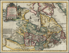
A Fine Map Illustrating Baron Lahanton's Longue River
This map was prepared to illustrated Lahontan's imaginary west to east Long River (Riviere Longue), rising in distant western mountains and emptying into the upper Mississippi. The map also shows the general region of Canada and the midwest which he explored.
The map extends east to the Great Lakes to show the Lac Superieur, Lac de Illinois (Michigan), and a number of the early French forts and fur trading outposts. Extensive annotations and diagrams are seen throughout the map.
Lahontan's map was one of the most influential of all mythical cartographic works, affecting the cartographic landscape of the upper Mississippi, Plains and Rocky Mountain Regions, for nearly fifty years. This map was issued in Noueaux Voyages de M. le Baron de Lahontan dans l'Amerique Septentrionale, one of the most influential yet fanciful works of its time. The map depicts the Longue flowing from the mountains in the west, likely the Rocky Mountains and connecting to the Mississippi River. On the western side of the mountains is another river, presumably flowing into the Pacific.
The map refers to several Indian tribes, the Tanuglauk, the Gnacsitares, and the Mozemleks [Mozeelek]. All of these appear to have been conjured by Lahanton's imagination, although he claims to have met members of all of these tribes in his texts and describes their encounters in detail. He claims that the western half of this map is a reproduction of a map the Gnacsitares made for him on a deerskin, and that it is accurate to "thirty minutes" (latitude and longitude). This is obviously false. In addition, he claims that the Mozemleks told him about Tanuglauk boats which could hold two hundred passengers and buildings eighty feet long, both of these which were drawn for him on tree bark and reproduced here. The amount of detail that Lahanton goes into to describe the provenance of his information is remarkable, particularly as none of it can be correlated by any other sources.
The eastern half of the map fairs little better in accuracy, despite supposedly being drawn by Lahontan's own observations. He claims to have traveled up the Long River to nearly the base of the Rocky Mountains, with a fleur de lys marking his highest ascent along the river. Despite this, there are some roughly correct observations. The Wisconsin [Ovisconsink] River is named, perhaps one of the earliest examples of this river being named. Melchisedech Thevenot's 1683 map shows the river but neglects to name it. The Illinois, Missouri, Wabash, and other branches are all named as well, but these lower branches were already relatively well known.
Nouveaux Voyages Dans L'Amerique Septentrionale
Lahontan joined the French Marine Corps and was sent to New France in 1683. He quickly learned the Indian languages and became adept in wilderness survival. He was sent to command Fort St. Joseph, near the present site of Port Huron, Michigan. He spent much of his time in America exploring the region. In 1688 he joined a party of Chippewa Indians in a raid on the Iroquois and later abandoned his fort and went to Michilimackinac. During the following winter he explored the upper Mississippi valley where he allegedly discovered the "Longue River". After several other adventures, including a successful attack on five English frigates in the Gulf of St. Lawrence, he eventually deserted the French military and returned to Europe.
Lahontan's Nouveaux voyages dans l'Amérique septentrionale (1703) was an immensely popular if somewhat fanciful account of his travels. While acknowledging the western terminus of his travels, Lahontan presented Native American reports of a great river, flowing to high mountains, with a great saltwater body beyond the mountains. Lahontan's account of these reports convinced many of the world's greatest intellects of the existence of this mythical waterway, which resulted in his account being accepted and incorporated by most of the major mapmakers of the period.
The Riviere Longue was reported along with a short pass through the mountains from which another river flowed (presumably) into the Pacific. He included accounts of Indian tribes who lived on islands in a great lake near the source of the river, and tales of crocodiles filling the waterways. He also used the book, in the form of a dialogue with an Indian named Adorio (The Rat), for a controversial attack on what were then-accepted doctrines of Christianity. The earliest known cartographic representations of the Rocky Mountains are influenced by his work, namely De L'Isle's 1700 map of North America.
Editions
Lahontan's map was originally published in 1703. This edition lacks a longitudinal scale, and is at a larger scale than some later editions. The numbering in the upper right can help to identify different editions, and lacks in the first edition.

![Fly to a Holiday on Continental [Golden Jet Souvenir Flight Map]](https://storage.googleapis.com/raremaps/img/small/90328.jpg)