|
||

|

|
|

|
Stock# 67743
Description
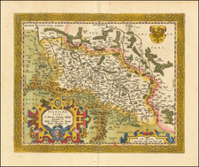
Rare early Dutch sea chart, published in Amsterdam by Jacob Colom.
The map covers the coastlines of western Poland, Pomerania and part of southern Sweden.
The chart appeared in one of the earliest Dutch Sea Atlases. The only example of the map we could locate in Phillips is an English edition (The Fierie Sea-columne. . . ) dated 1640. (Phillips 3331).

![[ Glasholm, Kalmar County, Sweden ] Geometirsk Charta ofver Glasholmen uti Calmare Lan Sodra Mores Harad och Halltorp Sockn forfattad af Landtmataren Samuel Frigelius Ao. 1797 -- Copierad uti Kongla Landtmateri Cont gt. Ao 1791.](https://storage.googleapis.com/raremaps/img/small/101424.jpg)
![Braunsviceensis et Luneburgensis Ducatuum Vera Delineat. [on sheet with:] Norimberg. Agri, Fidissima Descrip.](https://storage.googleapis.com/raremaps/img/small/85497.jpg)