|
||

|

|
|

|
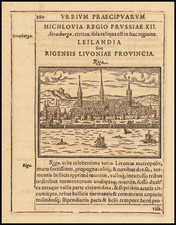
An attractive antique map of Riga as seen from the east. The city is portrayed in its eighteenth-century layout, with two sets of ramparts and moats. Across the "Duna" (Daugava) lies a small fort named "Kober Schantz." Important buildings are indexed.
The city pictured in detail, and its spires and landmarks are still recognizable today. The area of old Riga, now bounded by the Pilsetas Kanals (city canal), is labeled "statt Riga." Seven important buildings are named, including Riga Cathedral, the Churches of St. Jacob and St. Peter, the town hall, and Riga Castle. Surrounding the old city are hills and small fields, along with some buildings. "Jesus kirch" is labeled, standing approximately on the ground now occupied by the Lutheran Church of Jesus in the Maskavas Forstate district. The ramparts, defenses, and docks of the city are all labeled. The river appears to have changed course slightly, though some land reclamation has obviously already been undertaken along both banks.
The Kober Schantz is an interesting aspect of this map. It appears to be constructed in the estuarine environment of the Uzvaras Parks (Victory Park), which has similar emplacement and topography. The Freedom Monument perhaps even preserves a remnant of the moat, though its origins are difficult to follow. Historically, the Kober Schantz is no easier to chase up. Pierre le Grand (Petrus) makes a reference to the construction in his 1773 treatise on the Great Northern War. Riga was a particularly contentious city in this war, which had been controlled by Sweden since the Polish-Swedish War three-quarters of a century earlier. Petrus describes the assault on the Kober Schantz by Russian forces under Peter the Great during the 1710 Siege of Riga, which were eventually successful in taking the city. The fort would be renamed Peter-Schantz. It would appear that this fort also played a role in the 1701 Battle for Riga, of which much less is known. What became of this fort is unknown, but it was likely absorbed by the city as it grew in size over the 19th and 20th centuries.
Gabriel Bodenehr the Elder (ca. 1673-ca. 1766) was a German engraver and publisher. He originated views of many German cities, for example the first plan of Passau (1710), and is best known for his Atlas Curieux (1704). His son, Gabriel the Younger (1705-1779), followed his father in his profession and was also a well-known engraver.
![[ Estonia, Latvia, Lithuania ] Ducatuum Estoniae et Livoniae Tabula cum cursu Fluvii Dwinae](https://storage.googleapis.com/raremaps/img/small/62142.jpg)