|
||

|

|
|

|
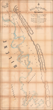
A Scarce Map Following Expeditions Exploring The Zambezi Basin
An antique map showing western half of Zambia, collating the results from several expeditions to the region which occurred at the end of the 19th century. The area shown extends into parts of Angola, the DRC, Zimbabwe, Namibia, and other neighboring countries. The area is shown in the most possible detail for the time, with a strong focus on topography, river systems, and more. The routes of early explorers, including Livingstone, Grey, the Rhodesian Company, and Selous are all shown. Particular focus is given to Major A St. Hill Gibbon's several expeditions, which are shown in orange.
The area on the map is at first difficult to recognize. Some lakes are shown which no longer exist, but some present-day lakes are yet to be formed. Most notable is the absence of Lake Kariba, the largest man-made lake in the world. It appears to occupy an area known as the Devil's Gorges, later renamed Kariba Gorges, now lost to the world due to the damming of the river. Victoria falls is shown, which had been known to Europeans since at least 1750, though Livingstone was the first European to see it. Upriver, the Zambezi appears to finger extensively in the region of the Liuwa plain, as it does today. Some features have changed, but the river and surrounding area are relatively accurately mapped, despite first appearances.
While the area around Zambia had been explored by some Europeans since the 18th century, accurate reports had to wait until the late 19th century. The "classical era'' of European exploration in Africa culminated with Henry Stanley and David Livingstone's encounter, giving way to a more scientific period of discovery. Livingstone's penultimate voyage before his disappearance and the subsequent encounter was to the Zambezi watershed, shown on this map. This expedition was regarded as a failure at the time, though he did pave the way for later explorers.
The post-classical era of discovery was more successful. The Scramble for Africa led to a slew of British and other expeditions to the region. Gibbons was by far the most prolific explorer to the region, following many of the major watersheds as shown on this map. His expeditions greatly increased European knowledge about the entire area, particularly the Zambezi and its tributaries. This would help set the stage for the final period of new imperialism. After the expedition, the British South Africa Company would start administering the region, and it would become a colony in the 1920s. The Anglo-German border, as shown on the map, would be redirected and completed. Expeditions such as Gibbon's, though benign at the time, were key to finalizing the exploitation of Africa.
This map was printed as part of the Royal Geographical Society Journal. This journal kept members up to date on the travels of the many explorers who reported to the Society. This journal distributed maps at the cutting edge of cartography throughout the 19th century, particularly regarding areas controlled by the British Empire. It was founded in 1831 and continues to be published.
We are unable to locate other copies of this map.
![[Southwestern Coast of Africa] Pas-Caart van Guinea en de Custen daer aen gelegen Van Cabo verde tot Cabo de Bona Esperanca](https://storage.googleapis.com/raremaps/img/small/46931.jpg)