|
||

|

|
|

|
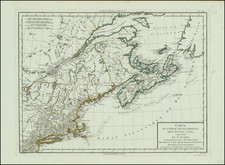
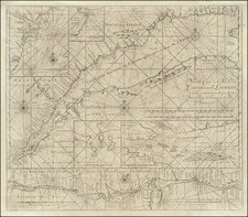
A rare English map of the St. Lawrence River, extending from Lake Ontario and Thousand Islands to just north of Quebec and Orleans Island. The chart shows channels, islands, shoals, waterfalls, rocks, and rapids in the river. Also shows towns, forts and place names in the river valley. A branch of the river, the Richelieu, is shown up to Lake Champlain. This depiction was originally an inset in D'Anville's four-sheet map.
The St. Louis River is one of the most populated parts of Canada in the present day, as well as being the heart of the historically French part of the country. The river had originally been named the Riviere du Canada but then renamed to match the Gulf it flows into. This area was an important theatre in the French and Indian War, the American Revolution, and the War of 1812.
The map is simple in its design, probably primarily made for river navigation. This simplicity, while preserving an exquisite amount of detail about the river, makes for a very attractive map of the region.