


|
||

|

|
|

|
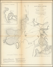
This is the earliest obtainable map of San Diego to show Mission Valley and the San Diego River with any significant detail. It was produced by what appears to be the Army Corps of Topographical Engineers, a short-lived but highly important branch of the Corps. The purpose of the survey was to collect information for constructions that would change the course of the San Diego River, altering its outflow from San Diego Bay to "False Bay;" the latter is now known as Mission Bay.
The map focuses on the area between San Diego Bay and False Bay. The old part of San Diego is shown in detail, and it is overlocked by Fort Stockton and the Presidio. Several roads are shown with their destinations including Los Angeles, the Mission, the Playa, and "New San Diego." Tidal and river channels are marked in detail, with those having water at low tide shaded. The two proposed channels are shown, along with their lengths. An inset shows the greater area, from approximately the present-day Silver Strand to Pacific Beach.
Detail is relatively accurate in this map. While Point Loma is shown as a bit more curved than it truly is, it is portrayed with an approximately correct length and shape. What draws the eye to anyone familiar with modern San Diego is the so-called False Bay, first named by the Spanish due to its poor navigability. At the time, the bay could only be entered through a small channel to the south, near the present outflow of the San Diego River. In reality, the area was more marshland than bay and was generally of little use to early Californian San Diego. Thus, it was likely rapidly mapped, leading to the omission of several islands as well as the peninsula of Mission Beach. Several other surveys at the time, including an 1844 French survey, had mapped the bay in much more accurate detail.
Over the next century, the present-day structure of Mission Bay would take form. Several early reclamation projects with an eye to housing and roads would take place, but the majority of the work would be done in the 1940s. As World War II was winding down, the city was worried it would lose its economy, and as such decided to build Mission Bay as a tourist destination. It is this project that defined the Mission Bay we see today.
The Changing Course of the San Diego River
Mission Valley was known to the Spanish as La Canada de San Diego, with the first mention of the San Diego River in the diary of explorer Sebastian Vizcaino. In 1602, Vizcaino left San Diego Bay to investigate what he called False Bay (now Mission Bay), noting that it was a "good port, although it had at its entrance a bar of little more than 2 fathoms depth, and there was a very large grove at an estuary which extended into the land, and many Indians." When the Spanish returned in 1769, Captain Vicente Vila noted the San Diego River was a river with excellent water with about forty Indians families living along the river. Vila led an exploration of the Valley and River in June of that year, and after rejoining Father Junipero Serra's land party, the Presidio at San Diego was constructed.
Over the years, the San Diego River changed courses between San Diego and False (Mission) Bay. During the mission era in San Diego, a dam and aqueduct were constructed in the first part of the 19th century. Using Indian labor, the missionaries dammed the San Diego River at the head of Mission Gorge and created a six-mile-long aqueduct to the fields of the mission.
Over time, the river increasingly impaired the navigability of the harbor, and the need for a dike was recognized. The San Diego History Center gives the following narrative about the construction of the dike:
In the U. S. Coast Survey of 1851, A. D. Bache warned that the bay may be destroyed by the silting action of the river. "The only remedy for this evil is to turn the river into False Bay again. This is an excellent harbor and its loss would be severely felt." In 1853, George Derby was sent to San Diego in 1853 to build what was to become known as Derby's Dike. On his survey map he noted that "during freshets of the rainy season, the marsh south of town is entirely' inundated as well as part of the valley and plain bordering on the river." Derby wanted to create a straight channel and levees for the river but he was ordered to deepen the old channel and build a levee from a point at the foot of the Presidio hill to the foot of Point Loma (1190 yards). The old San Diego Herald, Sept. 24, 1853; noted that "sixty laborers with carts, wheelbarrows, etc., are to be put on the work at once and by carrying it on energetically it is hoped that it may be entirely completed before the commencement of the rainy season." Derby complained that the plan was not sound, and funds were insufficient, and sure enough, the first "freshet" took out part of the dike, and in the heavy rains of 1855 the river went back into San Diego Bay.
The existing structure which eventually was deepened was likely the "Old Sandy Channel" marked on the map, and the dikes proposed here do not appear to have been constructed. Several floods in the following years would overflow the banks, even occasionally returning the flow of the river to the San Diego Bay, but it appears that the channel was mostly successful.
![[ Ocean Beach / Point Loma ] Map of Point Loma Electric Railway](https://storage.googleapis.com/raremaps/img/small/96377.jpg)
![Air Log Western Air Express [Los Angeles-San Diego, Las Vegas-Los Angeles, Milford-Vegas, Salt Lake City-Milford]](https://storage.googleapis.com/raremaps/img/small/85953.jpg)