


|
||

|

|
|

|
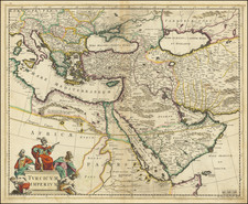
Early Appearance of Bischa for the Modern State of Qatar
Striking regional map of the Turkish / Ottoman Empire, centered on Turkey and Asia Minor, and showing the Eastern Mediterranean, Balkans, Greece, Persia, Saudi Arabia, the Black Sea and the Caspian Sea.
The map identifies the "Golfo di Bassora o D'Elcatif ol Sinus Persicus" and fascinating early recognition of the competing claims to control over the inland sea between the Arabian Peninsula and the Kingdom of Persia.
The appearance of the name Bischa is of perhaps greatest historical note. This would seem to be an early printed appearance of the name "Bishita," a name which dates back to the 8th and 9th Centuries, when it appeared in Eastern Syriatic documents of the Old Testament, "referencing the prosperity of the 'Bayt Qatarya' region." (see, Khalid Al-Jaber, Media In Qatar, Katara (Publishin House 2021), p. 23)
Includes a decorative cartouche in the lower left corner.
Tobias Conrad Lotter (1717-1777) is one of the best-known German mapmakers of the eighteenth century. He engraved many of the maps published by Matthaus Seutter, to whose daughter Lotter was married. He took over Seutter’s business in 1756. Lotter’s son, M. A. Lotter, succeeded his father in the business.
![[Greece & Turkey] Tabula Europae IX](https://storage.googleapis.com/raremaps/img/small/60122.jpg)
![[Iran & Iraq] Quinta Asie Tabula](https://storage.googleapis.com/raremaps/img/small/75299.jpg)