


|
||

|

|
|

|
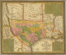
The Final Edition of the Mitchell-Young Map of Texas. One of Only Two or Three Known Examples.
Hand-colored engraved antique map of Texas as a republic, by S. Augustus Mitchell and J.H. Young. This is the last edition of the map, from 1845, and this is the only example that we have been able to trace. Streeter (1178G) notes an imperfect example at the University of Texas and his own copy.
According to contemporary newspaper articles, this edition was issued for sale in the summer of 1845, ten years after the first edition. The map proclaims the Republic of Texas and presents that Republic in its most expansive form, encompassing "Santa Fe formerly New Mexico" and the Wilson and Exeter Grant. The Young & Mitchell map started out as one of the earliest and most important maps in the founding cartographic sequence of Texas and features a wealth of information that makes it one of the most detailed and compelling contemporary depictions of the 'Lone Star Republic'.
In the early 1830s, the settlement of Texas and the rising tensions between the Anglo-Texan settlers and the Mexican government-generated intense interest amongst the American public. The publication of Stephen Austin's groundbreaking Map of Texas (1830) sparked a great appetite for new maps and geographical information on the region. Austin's map was soon followed by David H. Burr's Texas (1833). The first issue of the Young & Mitchell's A New Map of Texas was issued in 1835, on the eve of Texas's independence, with seven subsequent editions issued up to 1845. The Mitchell-Young map clearly follows the general format and scope of the Burr map, while preserving toponymic conventions from the Austin-Tanner.
The first edition of 1835 is rare and commands the highest price of any edition, however, the 1845 map is actually rare than that first edition.
The Young & Mitchell Map in Focus
The most engaging aspect of the map is its detailed labeling if the numerous 'empresario' grants, or Anglo-American colonies that make up much of Texas, each distinguished by bright original colors. In this, the final edition, many of the empresario grants have given way to an early county configuration, though the grants themselves are often still named.
Several key settlements are labeled, including San Antonio de Bexar ("usually called Bexar"), the largest town in Texas, founded in 1718, and the site of the Battle of the Alamo, fought in February-March, 1836, where Texan Independence fighters made a heroic stand against the Mexican army. Others include Brazoria, Harrisburg and Houston, and Nacogdoches, site of the first Spanish settlement in Texas (1716). Also included on the map are the routes of numerous roads, as while some of the rivers were navigable, they were considered the lifeline of the Republic.
The depiction of the northern and western frontier regions is captivating. While the delineation of the upper Rio Grande is less than precise, the interior lands feature a wealth of information. As Texas claimed the entire upper east bank of the river, it labels the region "Santa Fe formerly New Mexico", as both the towns of Santa Fe and Taos lay within Texas's enlarged boundaries. Expanses of territory, clearly beyond the practical control of Texan authorities, are shown to be dominated by the "Apaches Mescaleros" and "Comanche Indians". Other areas are labeled as "elevated prairies" or home to "Droves of Wild Cattle & Horses". The future state of Oklahoma, north of the Red River, is shown to be 'Indian Territory', where the U.S. Government had recently exiled Native American Nations form the Southeast during the 'Trail of Tears'. On the northern bank of the Red River is "Fort Towson", an important U.S. army outpost guarding the 'Permanent Indian Frontier'.
One will notice that the southern border of Texas, as shown on the map, runs along the Nueces River, to the north of the Rio Grande. This line was historically considered to be the southern frontier of Texas, however, during the War of Independence, the Texans expanded their claims southwards to the Rio Grande to embrace the so-called 'Nueces Strip' or 'Wild horse Strip' (named after the Wild Horse Desert). While the Treaties of Velasco (May 14, 1836), which ended the war, recognized the Strip as henceforth belonging to Texas, the Mexican government subsequently disputed the concession. The controversy over the ownership of the Nueces Strip was used as a pretext by U.S. President James Polk to instigate the Mexican American War in 1845.
The map is further embellished with lengthy and very interesting notes on the current state of Texas, included in three insets, entitled 'Remarks on Texas', 'Land Grants', and 'Rivers of Texas'. The remarks paint a highly favorable view of the region. As American sentiment heavily supported the Republic's independence (and the notion of Texas's future entry into the Union), the remarks are geared towards encouraging further Anglo-American settlement in the region. Highlights include, in:
The "Remarks on Texas" section differs from the first edition in that it includes a list of 32 Counties in Texas and a description of the Republic of Texas:
Those parts of Mexico, known by the names of Cohahuila and Texas, form one State in the Mexican confederacy, of which Texas is the easternmost and largest division. To the people of the United States, Texas is peculiarly interesting, from its immediate contiguity, and from the circumstance of Anglo Americans, forming the principal portion, of its rapidly increasing population. A soil of great fertility & a geographical position highly favorable to commercial intercourse, with the United States, and the rest of the World, are advantages which doubtless will at no distant period, render it an opulent and powerful State. A sea coast 350 miles in length, affords by means of its numerous rivers, communication at a number of points, with the Gulf of Mexico, which with the probable employment of steam navigation, on those streams susceptible of it, will speedily enhance the value, of the soil and its rich production. The face of the country is generally level, and a great portion of it consists of immense prairies; the soil of which is a rich deep black mold, mixed with sand; the bottom lands on many of the rivers, are of a rich red texture of great depth, and well timbered with cotton wood, walnut, cedar &c. Most of the productions of tropical climates grow here in great perfection; and the cotton is equal to the finest produced in the United States: the other products are sugar, tobacco, rice, indigo, wheat &c. Texas is one of the finest stock countries in the world. Cattle are raised in great abundance, and with but little trouble. Many of the settlers count their herds by hundreds; and great numbers are annually purchased, and driven to New Orleans by drovers, who visit the country for that purpose.
Counties in Texas.
1 Austin 2 Bastrop 3 Bexar 4 Brazoria 5 Colorado 6 Fannin 7 Fayette 8 Fort Bend 9 Galveston 10 Goliad 11 Gonzales 12 Harris 13 Harrison 14 Houston 15 Jackson 16 Jasper 17 Jefferson 18 Liberty 19 Matagorda 20 Milam 21 Montgomery 22 Nacogdoches 23 Red River 24 Refugio 25 Robertson 26 Sabine 27 San Augustine 28 San Patricio 29 Shelby 30 Travis 31 Victoria 32 Washington
The Republic of Texas extends from the Sabine river to the Rio del Norte and from the Arkansas to the Gulf of Mexico. It contains, 380,000 square miles of territory or 24,320,000 acres, and a population estimated at from 250,000 to 300,000. Austin the capital of Texas, is situated on the left bank of the Colorado river, about 200 miles from its mouth it is [15??] miles from Washington, 820 from Mexico, [???] from New Orleans and 255 from Galveston.
The "Rivers of Texas" section reads as follows:
The Sabine, Neches and Trinidad rivers are respectively 350, 300 and 410 miles in length; they are all navigable to a certain extent during a part of the year. The R. Brazos is considered the best navigable stream in Texas: vessels drawing six feet water can navigate it to Brazoria, and steam boats of light draught to San Felipe de Austin 90 miles higher, the tides ascend to Orazimba, at its mouth the R. Brazos is 200 yards wide and continues about the same to San Felipe. The lands on this river and on all the streams from hence to the Colorado inclusive, are the richest and deepest in Texas; and are considered equal in fertility to any in the world. The San Bernard is the most beautiful stream in Texas, it is navigable about 60 miles and has from 4 to 5 feet water on the bar. The Rio Colorado rises in the high prairies east of the Puerco R. and after a course of 600 miles flows into Matagorda Bay. About 12 miles above its mouth the navigation is obstructed by a raft of a mile in extent, beyond this light vessels may ascend it 300 miles. The La Baca, Guadalupe, San Antonio, and R. de las Nueces, are more or less navigable part of the year. The are, however but imperfectly known. The Rio del Norte, Rio Grande or Rio Bravo, has a course estimated from 1500 to 1700 miles in length, it has been ascended by a steam boat to Loredo upwards of 200 miles from the coast and persons acquainted with its navigation assert that it can be ascended by steam boats of light draught 500 miles further for at least seven months in the year.
Streeter Entry
Streeter, Bibliography of Texas (1178G) includes the following description, which is substantially, but not completely correct:
Young, James Hamilton, b. 1793. A New Map of Texas, with the Contiguous American & Mexican States by J.H. Young. Philadelphia: Published by S. Augustus Mitchell. Entered by S. Augustus Mitchell in the ... eastern district of Pennsylvania. [At foot, below neat line:] Engraved by J.H. Young. [At left of title:] Sold by Mitchell & Hinman No 6 North Fifth Street. 1845 1178G; Another edition [of entry No. 1178] , with the date 1845, with same title, copyright notice, scale, prime meridians, insets with changes in text, etc., as before, including "Sold by Thomas, Cowperthwait", etc., with three paragraphs on the "Government, &c. of Texas." on a printed slip pasted inside the front cover. Leather map case, as in the 1835 edition. The same plate is used for all editions of this map and it covers substantially the same area as the Burr map first published in 1833 (entry No. 1134). The 1835 edition (entry No. 1178A) of the Young map shows in colors, but on a considerably smaller scale, the land grants shown on the Burr map of 1833. These continue to be shown through the 1839 edition (entry No. 1178D), but in the 1842 edition (entry 1178E) counties take their place. The error in the Burr map of running the boundary between Texas and Louisiana about half a degree too far west is not repeated in the Young map and perhaps to emphasize this, the 1836, 1837, 1839, and 1842 editions of the Young map have a legend along this boundary reading, "Boundary of 1819." In the 1838 edition (entry No. 1178C) "City of Houston" appears for the first time, and the town of Aurora, not shown on modern maps, is located at the junction of the Neches and the Sabine. My copy of the 1842 edition is bound in with my copy in original cloth of Foote's Texas and the Texans, Philadelphia, 1841 (entry No. 1377). Young, born in Scotland in 1793, for several years, beginning about 1830, was employed by Samuel Augustus Mitchell to engrave the maps attached by Mitchell to his Guides and his Geographies. The Dictionary of American Biography in its article on Mitchell says that many of Mitchell's earlier maps "were engraved by J.H. Young, and compare favorably with the contemporary work of John Arrowsmith, the younger, distinguished English map maker."; Locations: TxU (imperfect). TWS.
For over fifty years, Samuel Augustus Mitchell, his son, and his successors some of the most prominent publishers of maps and atlases in the United States. Samuel Augustus Mitchell Sr. was born in Bristol, Connecticut on March 20, 1792. His father had emigrated from Scotland in 1773. While little is known about his early schooling, it is known that Mitchell found the quality of early geography text books to be lacking, and determined that he would write and publish better works. This decision led him to relocate to Philadelphia in 1829 or 1830, which was then the center of commercial publishing in America.
Mitchell’s first cartographic work was the re-issue of Anthony Finley’s New American Atlas in 1831, a work first issued by Finley in 1826, in response to Henry Schenk Tanner’s monumental work of the same title, issued in serial format from 1818 to 1822 and as a complete work from 1823 onward. While the map content in Mitchell’s edition of the New American Atlas is the same as Finley’s edition, each map has been significantly improved and revised, primarily with the addition of new towns and roads. This is especially true in the south and west. Finley had originally collaborated with D.H. Vance and J.H. Young in the preparation of the maps, although Vance’s name is removed from the Mitchell edition. Mitchell continued to work with Young, an association which would continue for several decades.
Following publication of the New American Atlas, Mitchell began issuing the individual maps in pocket map format. From 1834, Mitchell began offering reduced sized Tourist Pocket Maps of a number of states in the United States. J.H. Young and D. Haines are listed as the engravers on these maps. In 1832, Mitchell offered the first edition of his Travellers Guide Through the United States, A Map of the Roads, Distances, Steam Boat & Canal Routes &c. By J.H. Young . . ., which would become one of his most popular and enduring works. The map of the United States was done by steel engraving, one of the earliest uses of the technique in map publishing in America. In the same year, the first edition of Mitchell’s Map of the United States, by J.H. Young was issued, bearing the copyright date of October 10, 1831. This map would be revised and issued until 1844. Young also compiled A New Map of the United States in 1833. These two wall maps would come to dominate the market and their success led to several later US wall maps issued by Mitchell. This second map was also issued under the title of Mitchell’s Reference and Distance Map of the United States, which was printed until 1851.
Mitchell was neither a cartographer nor an engraver. His primary function was as the editor and business manager of his publishing company, with Young working as the primary maker of maps. Beginning in 1839, Mitchell also began publication of his school atlas. This work and variant editions for older and younger students, was issued by Mitchell and his successors from 1839 to 1886. In 1845, Mitchell acquired the rights to Henry Schenk Tanner’s New Universal Atlas from Carey & Hart, which had previously acquired the copyright from Tanner and had published editions of 1843 and 1844. Mitchell changed many of the maps and issued two editions of the atlas in 1846. He changed the copperplates to lithography, utilizing Peter S. Duval in Philadelphia to produce the stones. Mitchell re-issued the atlas at least annually until 1850, when he sold the rights to the work to Thomas, Cowperthwait & Company.
In 1860, Mitchell’s son, Samuel Augustus Mitchell Jr. began issuing Mitchell’s New General Atlas. While his father had continued to issue wall maps and other works, this appears to be his son’s first entry into the trade. The New General Atlas was issued by SA Mitchell Jr. until 1887. From 1880 to 1887, Bradley & Company also published the atlas. Various other minor publishers, including A.R. Keller, produced editions as late as 1894. The elder Mitchell died in 1868. Samuel Jr. continued the business until the 1890s. At its height, the Mitchell Company employed 250 people and sold 400,000 publications annually.
![Mexico [with Southwestern U.S., Texas, etc.]](https://storage.googleapis.com/raremaps/img/small/97606.jpg)
![[Restricted] New Orleans (0-6)](https://storage.googleapis.com/raremaps/img/small/68648.jpg)