


|
||

|

|
|

|
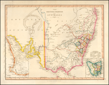
Striking, Intricate Arrowsmith Map of Western Australia with Details from Recent Explorations By The Future Prime Minister of New Zealand
Finely-detailed map of Western Australia by London’s premier cartographer of exploration, John Arrowsmith. The map details the expedition of George Grey, later Prime Minister of New Zealand.
Arrowsmith was the unofficial mapmaker of the Royal Society, of which he was also a founding member. He prepared the maps for many explorers’ publications, including those in George Grey’s Journals of Two Expeditions of Discovery in North-West and Western Australia, During the Years 1837, 38 and 39, Under the Authority of Her Majesty's Government (London: T.W. Boone, 1841), in which this map featured. His route is marked in red on the map.
The map features the western coastline of Australia from 24°S to 32°S latitude. The large inset in the upper right corner shows a close-up of 27°S to 30°S, which had recently been explored by Captain George Grey. In the lower left corner are three smaller insets, of Port Grey, Warnbro Sound, and Peel Harbour.
The coastline is carefully annotated with obstructions, sand bars, and soundings. Passages into tricky harbors are included, as are the bearings of important landmarks near shore. Notes explain the nature of the soil and vegetation, and where fresh water can be found.
There is little information available for inland areas, except around Perth. There, there are county lines and names, rivers, settlements, hills, and peaks. This detail is the result of expansion of the Swan River Colony, which had been established in 1829.
Arrowsmith’s name is not only in the title and the publication information. He also has a mountain named for him in Beaufort County, and a river in the upper right inset. Arrowsmith’s name is also featured elsewhere, especially in Canada, a testament to his influence among British explorers in the nineteenth century. The Arrowsmith River also garners the largest text block on the map. It reads:
The Arrowsmith is a very large Riv._its bed is 200 yds. wide & 50 or 60 ft. deep, the trunks of immense [illegible] washed down in the floods, lie scattered on the ground about its banks_no water in the Riv. where we crossed without digging a few inches in the sand_large pools immediately above & below us. It drains extensive vallies running N. & S. between the interior range & the sandy limestone range parallel to the coast_it probably comes through the range as other streams do_its main course from the interior appeared to be from E.S.E. many natives came to drink at it_From a range 1 ½ mile Sth. of the riv. is a fine view of the rich vallies which this important riv. drains.
Exploration of Western Australia
Indigenous peoples have lived in Australia for 40,000 years. As was common with maps and charts of the nineteenth (and earlier) centuries, their presence is not recognized here, except in brief notes like the above. Instead, the tracks and names of European explorers—Dutch, British, and French—feature heavily, offering a history of the European encounter with this shore.
The first Europeans to contact Western Australia were the Dutch. En route to the East Indies, many Dutch traders decided to brave the fierce winds of the Roarin’ Forties (latitude) to speed their journey. However, this gamble sometimes resulted in being blown too far, onto an unknown (to Europeans) shore.
The first European to contact Western Australia was Dirk Hartog. He landed on what is now known as Cape Inscription, on Dirk Hartog Island. The island is included here. The crew of Hartog’s ship, the Eendracht, commemorated their discovery by erecting a post with a pewter dish inscribed with their ship’s information—the earliest physical record that historians have of any European landing in Australia. This plate was recovered in 1696 by Willem de Vlamingh; he replaced the plate with another and returned the original to Amsterdam.
Another Dutch place name, mentioned prominently in the title, are the Houtman’s Abrolhos. Jacob d’Edel, in the Amsterdam, along with Frederik de Houtman in the Dordrecht, came within sight of the western coast in 1619 and called the stretch of land near Perth d’Edelsland. The Houtmans Abrolhos are an archipelago, as shown, and are named for the navigator who sighted them, or at least it was Houtman who reported the islands to the Dutch East India Company (VOC). The name Houtmans Abrolhos was first used in Hessel Gerritszoon’s 1627 chart Caert van't Landt van d'Eendracht.
It was on these islands that the Batavia famously wrecked in 1629, on its maiden voyage. Mutiny and murder followed. The tragedy is commemorated here with several place names: Pelsart Group (Pelsaert commanded the Batavia), Wreck Point, and Batavia Road. To the south, the island of Turtle Dove, initially sighted by the Dutch ship the Tortelduyf, is thought to be “very doubtful” by nineteenth-century standards.
By the end of the seventeenth century, the VOC had largely abandoned the idea of a colony or outpost in Western Australia. The first British navigator to spend significant time in the area, William Dampier, agreed. He named Shark Bay, also listed prominently in the title here, during his voyage in 1699. He also called the aboriginal peoples he encountered there the most miserable people in the world, a pejorative description that unfortunately continued to circulate for decades thanks to the popularity of Dampier’s voyage accounts.
In 1772, the Frenchman Louis Aleno de St Aloüarn claimed Western Australia for France from his anchorage on Dirk Hartog Island. In 1801, the French ships Géographe and Naturaliste, under the command of Nicolas Baudin and Emmanuel Hamelin, surveyed much of the western coastline. Their impact is seen in place names like Geographe Channel, Naturaliste Channel, Hamelin Harbour, and H. Freycinet Harbour.
Louis-Claude de Freycinet was the main hydrographer on the Baudin voyage who oversaw the publication of its account and atlas. The harbor here was named for Louis-Henri de Freycinet, his brother who was also on the expedition. Freycinet and the Baudin expedition were charting Western Australia at the same time a British expedition, under the command of Matthew Flinders, was doing the same; Flinders’ would eventually complete the first circumnavigation of Australia. He was detained by the French, however, and delayed in publishing his findings. Louis de Freycinet returned in command of his own expedition in 1818, when he found the plate left by Willem de Vlamingh and took it to France.
The Swan River Colony and later exploration
The mouth of the Swan River was first depicted by the Dutchman Willem de Vlamingh during his 1696-7 expedition along the coast. In 1827, spurred by reports of French interest and American whaling, Western Australia was claimed for Britain at a ceremony in King George Sound, on Australia’s south coast. This commemorated a similar claim made in the same spot in 1791 by George Vancouver. However, there were still no permanent European settlements in the region.
Captain James Stirling and botanist Charles Frazer sought to find fertile land for a settlement. They thought they had found it at the Swan River, although they overestimated the agricultural potential of the area. Stirling returned to Britain to advocate for the creation of a free colony at Swan River, Australia’s first non-penal colony (convicts would be introduced in the 1850s). In 1829, Captain Charles Fremantle again claimed the Swan River Colony and surrounding territory for Britain. Stirling became the Lieutenant Governor of the colony, founding Perth (named 1832) twelve miles inland from the future port to be named for Fremantle. Both are seen here.
The counties anticipated droves of settlers to seek a home in the west. Four thousand people flocked to the nascent settlements in 1829-30 alone. They found harsh conditions, a rough climate, and understandable resistance by aboriginal peoples to the takeover of their land. Only 1,500 settlers remained by 1832. Despite these setbacks, the colony began to feed itself by 1835 and to export wool in 1836. They spread from Perth, looking for arable land. In 1840-41, when this map was made, London investors planned another settlement, Australind, 160 miles south of Perth. However, the plan had failed by 1843.
Hydrographic surveys of Western Australia
As the area became settled, however sparsely, further exploration was necessary. Much of this reconnaissance was hydrographic in nature. Arrowsmith sites the surveys of King, Wickham, and J. S. Roe. Captain Phillip Parker King commanded four surveying expeditions around Australia from 1817 to 1822, which included the western coastline. King was later assigned to the HMS Adventure, accompanied by the HMS Beagle, the world’s most famous surveying ship, on the latter’s first survey voyage to Patagonia from 1826 to 1830.
Captain John Clements Wickham, in command of the Beagle, surveyed Western Australia from 1837 to 1843, the ship’s third survey expedition. He also sailed as first officer on the Beagle’s second survey mission from 1831-36, the voyage on which Charles Darwin sailed. Wickham and his crew are credited with finding evidence of the wrecks of two VOC ships, including timbers of the Batavia at Wreck Point in 1840.
John Septimus Roe sailed as a young officer with Phillip Parker King on his Australian surveying voyages. After serving in the First Anglo-Burmese War, Roe was offered the position of Surveyor-General of Western Australia. Roe and his family arrived with the first colonists to the Swan River Colony aboard the Parmelia in 1829. Roe chose the sites for Perth and Fremantle and laid out the towns. He also surveyed the surrounding area, leading many expeditions into the interior and along the coast from 1829 to 1849. He was the first to survey Peel Harbor and Warnbro Sound, which are insets here.
The expeditions of George Grey
The final explorer to mention with regard to this map is Sir George Grey. His name is commemorated in several notes and in Port Grey, which also has its own inset. His track is shown in red and it is his account in which this map was included.
George Grey was a soldier who led two expeditions in Western Australia from 1837 to 1839. Grey was given command at only 25 years of age, ordered to investigate if an Australian river emptied into the Indian Ocean at any point along the coast. The expedition was supported by the Royal Geographical Society and therefore, tacitly, by John Arrowsmith.
Woefully inexperienced and unprepared, Grey and his men began their first foray near Hanover Bay, northwestern Australia (not shown on this map). They experienced floods and extreme thirst, Grey was stabbed by a spear, and they had to be rescued by the Beagle, upon which Grey had sailed to Cape Town from England.
He then traveled to Perth in late 1838. By February 1839, Grey was ready for another excursion. This time he and his men sailed to Shark Bay. They were supposed to explore to the northwest, but were met with fierce weather. They crossed to the mainland, as seen here, making it to the Gascoyne River. They decided to turn south, for Perth, in a small boat. The boat was wrecked at Gantheaume Bay (see inset, upper right), forcing the explorers on a 300-mile overland journey. They survived thanks to the help of Kaiber, a Whadjuk Noongar man.
Despite these two disastrous journeys, Grey was promoted captain and appointed as resident magistrate of King George Sound. He published Vocabulary of the Dialects spoken by the Aboriginal Races of South-Western Australia, which was later reprinted in London (1840). Grey then returned to England to promote settlement in Western Australia. He completed Journal of Two Expeditions of Discovery, with maps by Arrowsmith, while in Brighton.
Grey was then named Governor of Southern Australia. Later, he served as the Governor of New Zealand from 1845 to 1853, and again from 1861 to 1868. In the interim, he was Governor of the Cape Colony. From 1875 to 1895, he served in the Parliament of New Zealand, becoming Prime Minister from 1877 to 1879. In 1894, Grey returned to England, dying in London in 1898.
States and rarity
This is the second state of the map, which was first published in 1840. This second state removes “Australind” from the phrasing with “Port Grey”, as the former is too southerly to be included here. The second state also includes the insets in the bottom left corner.
Grey’s Journals have endured as important sources on aboriginal languages and culture. They have been reprinted several times, but usually without the full-scale, original maps. This map appeared in the original Journals, as well as some examples of Arrowsmith’s London Atlas of Universal Geography (for example, a copy in the British Library, dated 1847). It is held by a limited number of institutional collections and is not common on the market.
The Arrowsmiths were a cartographic dynasty which operated from the late-eighteenth century to the mid-nineteenth. The family business was founded by Aaron Arrowsmith (1750-1823), who was renowned for carefully prepared and meticulously updated maps, globes, and charts. He created many maps that covered multiple sheets and which were massive in total size. His spare yet exacting style was recognized around the world and mapmakers from other countries, especially the young country of the United States, sought his maps and charts as exemplars for their own work.
Aaron Arrowsmith was born in County Durham in 1750. He came to London for work around 1770, where he found employment as a surveyor for the city’s mapmakers. By 1790, he had set up his own shop which specialized in general charts. Arrowsmith had five premises in his career, most of which were located on or near Soho Square, a neighborhood the led him to rub shoulders with the likes of Joseph Banks, the naturalist, and Matthew Flinders, the hydrographer.
Through his business ties and employment at the Hydrographic Office, Arrowsmith made other important relationships with Alexander Dalrymple, the Hudson’s Bay Company, and others entities. In 1810 he became Hydrographer to the Prince of Wales and, in 1820, Hydrographer to the King.
Aaron Arrowsmith died in 1823, whereby the business and title of Hydrographer to the King passed to his sons, Aaron and Samuel, and, later, his nephew, John. Aaron Jr. (1802-1854) was a founder member of the Royal Geographical Society (RGS) and left the family business in 1832; instead, he enrolled at Oxford to study to become a minister. Samuel (1805-1839) joined Aaron as a partner in the business and they traded together until Aaron left for the ministry. Samuel died at age 34 in 1839; his brother presided over his funeral. The remaining stock and copper plates were bought at auction by John Arrowsmith, their cousin.
John (1790-1873) operated his own independent business after his uncle, Aaron Arrowsmith Sr., died. After 1839, John moved into the Soho premises of his uncle and cousins. John enjoyed considerable recognition in the geography and exploration community. Like Aaron Jr., John was a founder member of the RGS and would serve as its unofficial cartographer for 43 years. Several geographical features in Australia and Canada are named after him. He carried the title Hydrographer to Queen Victoria. He died in 1873 and the majority of his stock was eventually bought by Edward Stanford, who co-founded Stanford’s map shop, which is still open in Covent Garden, London today.
![(Australia) Australien - Ubersicht des Standpunkets der geographischen Kenntniss von Australien, 1868, & Dr. Neumayer's Projeket zur wisseschaftlichen Erforschung Central-Australiens [Survey of the Standpoint of the Geographical Knowledge of Australia, 1868, & Dr. Neumayer's project for the scientific investigation of central Australia]](https://storage.googleapis.com/raremaps/img/small/85398.jpg)
![[ New South Wales Electors in 1871 ] Map Shewing Roads & Postal Stations in New South Wales Prepared for the Use of the Post Office Department](https://storage.googleapis.com/raremaps/img/small/88237.jpg)