|
||

|

|
|

|
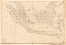
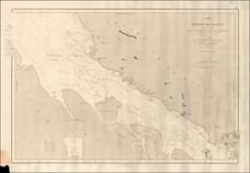
British Admiralty Map Centered on Singapore Island
A wide nautical chart showing the area around the Straits of Singapore, including Singapore Island, Batam Island, Bintan Island, and the islands off the eastern coast of Sumatra. As with all British Admiralty maps, nautical detail is extensive. Soundings are marked across the main strait and other areas, and shoals, buoys, ammunition dumping grounds, and much more are all marked. This map, which has always been the site of one of the world's busiest shipping lanes, would have been widely used throughout the twentieth century.
It is, of course, this convergence of global trade which has made Singapore one of the most successful city-states in modern times. Here, the city preserves its layout from the early 1930s. The Marina would not be filled in until the 1980s, so Fort Canning and the Governor's house are still nearly on the water. This helps to explain why the old center of Singapore is so far inland today. Most of the settlement is centered on the Fort Canning area. Grange Road can be followed through the yet-to-be-built upscale Orchard and Tanglin neighborhoods through to a collection of buildings at Holland, now comprising the popular Holland Village area. Most of the rest of the island is shown as hills or jungle. A small airport is marked on the eastern end of the island, next to Changi Hill.
Singapore was going through a tumultuous period in its history while this map was being updated. The Japanese invasion had reduced confidence in the British government, and the subsequent post-war period was particularly violent. The Malayan Emergency, a guerrilla insurgency, and various riots all had to be dealt with in order to establish the Singaporian Republic. This period would define the tendencies and rule of the early republic, and it still has repercussions in the country to this day.
Returning to the navigational purposes of this chart, the map includes several insets. One provides detailed tidal information for various areas through the Malacca Strait, Bulan Strait, Singapore Strait, and greater South China Sea. Particularly strong regular and tidal currents are marked. Another inset shows the larger scale charts which also map the same area in more detail.
The British Admiralty has produced nautical charts since 1795 under the auspices of the United Kingdom Hydrographic Office (HO). Its main task was to provide the Royal Navy with navigational products and service, but since 1821 it has also sold charts to the public.
In 1795, King George III appointed Alexander Dalrymple, a pedantic geographer, to consolidate, catalogue, and improve the Royal Navy’s charts. He produced the first chart as the Hydrographer to the Admiralty in 1802. Dalrymple, known for his sticky personality, served until his death in 1808, when he was succeeded by Captain Thomas Hurd. The HO has been run by naval officers ever since.
Hurd professionalized the office and increased its efficiency. He was succeeded by the Arctic explorer Captain William Parry in 1823. By 1825, the HO was offering over seven hundred charts and views for sale. Under Parry, the HO also began to participate in exploratory expeditions. The first was a joint French-Spanish-British trip to the South Atlantic, a voyage organized in part by the Royal Society of London.
In 1829, Rear-Admiral Sir Francis Beaufort was appointed Hydrographer Royal. Under his management, the HO introduced the wind force scale named for him, as well as began issuing official tide tables (1833). It was under Beaufort that HMS Beagle completed several surveying missions, including its most famous voyage commanded by Captain FitzRoy with Charles Darwin onboard. When Beaufort retired in 1855, the HO had nearly two thousand charts in its catalog.
Later in the nineteenth century, the HO supported the Challenger expedition, which is credited with helping to found the discipline of oceanography. The HO participated in the International Meridian Conference which decided on the Greenwich Meridian as the Prime Meridian. Regulation and standardization of oceanic and navigational measures continued into the twentieth century, with the HO participating at the first International Hydrographic Organization meeting in 1921.
During World War II, the HO chart making facility moved to Taunton, the first purpose-built building it ever inhabited. In 1953, the first purpose-built survey ship went to sea, the HMS Vidal. Today, there is an entire class of survey vessels that make up the Royal Navy’s Hydrographic Squadron. The HO began to computerize their charts in the late 1960s and early 1970s. In 1968, the compilation staff also came to Taunton, and the HO continues to work from there today.
![[ Singapore ] Singapur](https://storage.googleapis.com/raremaps/img/small/100947.jpg)