|
||

|

|
|

|
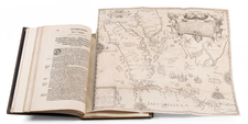
Circa 1505 T-O World Map.
An attractive example of the circa 1505 Venice edition of Zacharias Lilius's geographical gazetteer, incorporating two post-incunable woodblock T-O world maps.
The top world map shows the polar, tropical, and equatorial zones from the ancients. The world map below it is in the traditional form with east at the top and Europe, Africa, and Asia separated by the Mediterranean, Nile, and Tanais (Black Sea or Don River).
Lilius (or Zacaria Lilio), Bishop of Sebaste, was an early compiler of a geographical gazetteer that incorporated the writings of ancient and medieval geographers. Lilius's geographical dictionary was a compendium of descriptions of Europe, Africa, and Asia (predating Columbus's discovery of America), and his index lists over 260 cities. This edition of the geographical dictionary was published in Venice by Joannes & Gregorius de Gregoriis de Forlivio.
Rarity
Though the book is reasonably well represented in institutional holdings (38 records in ISTC), it is very scarce on the market; RBH locates only one example appearing at auction in the last 20 years.