


|
||

|

|
|

|
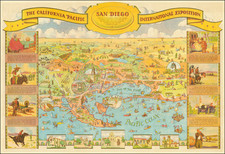
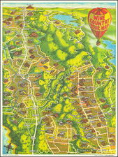
This is one of the great California caricature maps, showing San Diego on one side and Balboa Park on the verso. This edition was prepared by Shell Oil Company for the 1935 California Pacific International Exposition. The map was drawn by Don Bloodgood, a noted illustrator of maps, postcards and similar ephemera during the period, and the original envelope it was sent in is included.
The San Diego side contains all the neighborhoods of the city from Pacific Beach to the border and shows the region inland as far as Cuyamaca. Vignettes around the side of the map provide some historical context, but the true interest lie in the map itself, which provides a unique view of the city at the end of the Depression. Downtown San Diego is the only densely built-up area, though various small towns exist in Pacific Beach, Loma Portal, National City, and Chula Vista. No major settlements are shown inland. Poway Valley is full of vineyards, while El Cajon Valley has some orchards. Further inland ranchers can be found. The military presence is visible throughout the city, with the area now known as Kearny Mesa marked as "Formerly Camp Kearny." Street names have changed as well, with Atlantic Street being replaced by the (more accurately named) Pacific Highway. This renaming was done in June of 1935, likely in conjunction with the exposition.
The verso shows the California Pacific International Exposition which occupied the area now known as Balboa Park. Balboa Park had been built during the 1915 Panama-California Exposition, and the supposedly temporary buildings had been preserved for their scenic value, just like the Eiffel Tower. This exposition extended from North Park to the edge of the downtown area. Several new monuments were constructed during this fair, including the Old Globe, Ford Building, and International Cottages, some of which can be seen in this image. This event was intended to jump-start the local economy after the Depression, and it was successful enough to be conducted over a second year.
Each side is decorated with countless caricatures and figures. Boats of all sorts sail through the Pacific and into San Diego Harbor, and action can be found everywhere on land. Many sights of the exposition, real and humorous, are included, though some of the raunchier exhibits, such as the Zoro Garden Nudist Colony, are omitted. Surrounding the verso is a decorative border depicting life in early San Diego.
Many additional factoids scatter the maps. Some, such as the claim that the California missions were so spaced because that was how far Serra could ride a burro in a day may be more legend than fact, though many true pieces of interest can be found.
In all, this makes for an extremely attractive Depression-era pictorial map of San Diego and the California Pacific International Exhibition.
![(Franco-Prussian War) Fameux Probleme Algebrique & Politique [Famous Algebraic & Political Problem]](https://storage.googleapis.com/raremaps/img/small/86125.jpg)