|
||

|

|
|

|
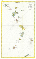
A nice example of this scarce map of from the Jeffery's West India Atlas. The map includes an ornate compass rose, approximately twenty place names, roads, topographical details, and more. The map is attractively and simply laid out.
Bequia, the name which stuck to the island, is one of the southernmost islands of the Lesser Antilles. Several of the toponyms have changed since the publication of the map, but the sound on the west coast is still referred to as Admiralty Bay. The small collection of buildings on its shores has grown into Port Elizabeth, the largest town on the island with a population of 4,000.
Bequia played an interesting role in the life of Alexander Hamilton. His father, James Hamilton, moved there in 1774 from St. Croix. Alexander repeatedly asked James to visit him in the United States, even sending him money to do so, but the latter never came.
The first edition of this map was created by Jeffreys, but it was not published until after his 1771 death. Sayer and Bennet first published the map in 1775, and updated it in several subsequent editions. Laurie and Whittle acquired the plates upon Robert Sayer's death in 1794.
James Whittle (1757-1818) was a British engraver and map printer. Whittle was employed by Robert Sayer (ca. 1725-1794). Together with Robert Laurie (1755?-1836), he took on Sayer’s business when the older man died in 1794. The two traded together as Laurie & Whittle until 1812, when Laurie retired. They had specialized in sea charts and maritime atlases. Whittle then partnered with Laurie’s son, Richard Holmes Laurie, until he died in 1818.
Robert Laurie (1755?-1836) was a British engraver and printseller who specialized in engraving portraits and in publishing maritime charts. His family originated in Dumfriesshire. As a young man he came to London and was apprenticed to Robert Sayer (ca. 1724-1794) in 1770. He received several awards in the 1770s for his mezzotint engraving and printing. He worked for Sayer as apprentice, assistant, and later partner.
In 1794, when Sayer died, Laurie took on his business alongside James Whittle, his fellow Sayer employee. Laurie managed the business and ceased almost all engraving. Instead, he oversaw the prodigious output of printed materials, especially sea charts and maritime atlases. He retired in 1812.
Laurie’s son, Richard Holmes Laurie, took over his part of the business and continued in business as Whittle & Laurie, rather than the previous Laurie & Whittle. Whittle died in 1818, leaving Richard as the sold proprietor of the business. Robert died in 1836 in Hertfordshire.
![Cuba Insula [with] Hispaniola Insula [with] Insula Jamaica [with] Ins. S. Ioannis [with] I.S. Margareta Cum Confiniis](https://storage.googleapis.com/raremaps/img/small/95802.jpg)
![Cuba Insula [with] Hispaniola Insula [with] Ins. Jamaica [with] Ins. S. Ioannis [with] I.S. Margareta [with] Havana portus](https://storage.googleapis.com/raremaps/img/small/95302.jpg)
![[Heighted with Gold] Pascaert Vande Caribes Eylanden](https://storage.googleapis.com/raremaps/img/small/91150.jpg)
![[St. Barths, Nevis, St. Martins, St. Kits, Antigua, Barbuda, Anguilla, Guadalupe, Dominica, etc.] Geographical, Statistical and Historical Map of The Leeward Islands](https://storage.googleapis.com/raremaps/img/small/52732.jpg)