|
||

|

|
|

|
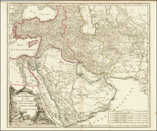
Jordan Makes the Most of Their Annexation of the West Bank.
Scarce bilingual (English and Arabic) pictorial tourist map of Jordan, with extensive illustrations in the borders featuring the country's archaeological sites. The verso has maps of Amman and Jerusalem, the latter of which, after the 1948-49 annexation of the West Bank, was partially under Jordanian control. Part of Jerusalem is labeled "Ex-Jewish Quarter".
Israel is prominently labeled "Occupied Territory of Palestine".
There is a small inset map of international boundaries for countries in the region showing Egypt, Saudi Arabia, Iraq, and Syria, but leaving Israel blank.
After the Jordanian annexation of the West Bank, Transjordan was renamed the Hashemite Kingdom of Jordan.
The map features pictorial vignettes of important archaeological sites and monuments in the region, including the Dome of the Rock and Khirbet Qumran, the latter famously associated with the Dead Sea Scrolls. Also depicted is the famous rosette of Qasr Hisham, an important cultural treasure in Palestine.
This map was made before the 1967 Six-Day War, at the conclusion of which Jordan lost control of the West Bank (and Egypt temporarily lost the Sinai Peninsula).
Rarity
The map is quite rare and we have been unable to find any other examples.
![[Haifa] Situation Plan von der Deutschen Colonie bei Haifa rep.](https://storage.googleapis.com/raremaps/img/small/61139.jpg)

![(Nuremberg Chronicle) [Saul and Odysseus]](https://storage.googleapis.com/raremaps/img/small/98684.jpg)