


|
||

|

|
|

|
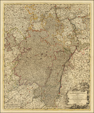
Manuscript Map Showing Land in the German State of Hessen
Finely-wrought topographic manuscript map showing the Schwalm-Eder-Kreis, or the Schwalm-Eder district.
The document, on the verso, is titled “Gorge de Karlenhausen,” the name of one of the small towns marked by rectangles with red dots. The east-oriented map shows a large gorge with sloping hills, with the river running through the top of the feature. Several towns are included, most located along the river and its tributaries. Roads are also shown, connecting the villages to each other.
Many of the towns are recognizable, but they are known by slightly different names today. From the right, there is Neuental-Schlierbach (Schlierbach on the map), Neuental-Gilsa (Gilsen), Neuental-Bischhausen (Bischhausen), Bad Zwesten-Niederuff (Niderruff), Bad Zwesten-Oberruff-Schiffelborn (Oberuff), Burg Löwenstein (Castle Löwenstein, Löwenstein on the map) and Bad Zwesten (Zwiste).
There are still castle ruins at Burg Löwenstein. As seen here, the area is largely rural and hilly. It gets its name from the Schwalm and Eder Rivers which run through the district. The Schwalm is labeled on this map.
The map is finely drawn by a skilled hand. The paleography suggests a creation date of the early-nineteenth century. Districts were designated in the area in 1821, so this map likely dates to roughly that time.

![[Course of the Rhine River] Nova Tractus Totius Rheni Oder Neue beschreibung des Rhein-Strom](https://storage.googleapis.com/raremaps/img/small/58670.jpg)
![[ Jülich Kleve ] De Hertochdommen Gulick Cleve Berghe en de Graeffchappen vander Marck en Ravensbergh . . . 1610](https://storage.googleapis.com/raremaps/img/small/99226.jpg)
![Les Cercle de la Haute Saxe ou sont compris Le Duche et Eslectorate de Saxe Les Marquisats de Misnie, et de Lusace la Landgraviate du Thuringe…Le Brandebourg, et la Pomerainie [The Circle of Upper Saxony, including the Duchy and Electorate of Saxony, the Margraviates of Meissen and Lusatia, the Landgraviate of Thuringia...Brandenburg, and Pomerania.]](https://storage.googleapis.com/raremaps/img/small/92654.jpg)