


|
||

|

|
|

|
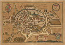
A striking and detailed town plan, with vignettes of Plymouth Sound, The Column, and Plymouth Harbor. The map is attractively colored and shows a large amount of detail about the city including railroads, ramparts, government offices, and much more.
Plymouth was one of the most important ports on the British mainland. While not as protected as Bristol or Portsmouth, it was strategically located on the southwestern coast, facing France. It had fallen out of favor during the 17th century due to its remote Devon location and the cost of transport, but the development of railways and increased New World trade brought it a new status. Perhaps most importantly for the continued significance of the city, the Royal Navy had a major base in Plymouth Dock, renamed to Devonport in 1824 and shown on this map. The three urban centers shown on this map, Plymouth, Stonehouse, and Devonport, would not merge to form the city of Plymouth until 1928.
Plymouth remains an extremely attractive city and a popular holiday destination, as well as being a primary economic center for the southwest. The Column still stands near the docks in old Devonport, and the edges of the sound still remain agricultural. Drake's Island, pictured in the Plymouth Sound vignette, remains little changed.
Tallis was one of the last great decorative map makers, and his maps were prized for their attractive vignettes and imagery. This example was engraved by H. Bibby and J. Rapkin.
John Tallis (1817-1876) was a British map publisher. Born in the Midlands, Tallis came to London in the 1840s. Tallis began his London career with a series of remarkable London street views. He began a partnership with a Frederick Tallis, possibly his brother, but their collaboration ended in 1849. For the Great Exhibition of 1851, Tallis published the Illustrated World Atlas, one of the last series of decorative world maps ever produced. The maps were engraved by John Rapkin, a skilled artisan. The maps were later reissued by the London Printing & Publishing Company, who left the Tallis imprint intact, thus ensuring his enduring fame. In 1858, he began publication of the popular Illustrated News of the World and National Portrait Gallery of Eminent Personages, selling it in 1861 (it ceased publication in 1863).
![[ Wight ] Isle de Wigh](https://storage.googleapis.com/raremaps/img/small/98047.jpg)
![Regionis, quae est circa Londinum specialis repraesentatio geographica, ex autographo majori Londinensi . . . 1741 [Includes Bird's-eye View of London and Westminster]](https://storage.googleapis.com/raremaps/img/small/95041.jpg)
![[ London to Dorchester and Bensington ] The Road from London to St. David's com Pembroke . . .](https://storage.googleapis.com/raremaps/img/small/100748.jpg)