|
||

|

|
|

|
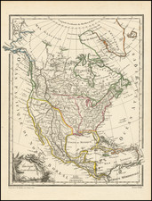
An excellent little map of North America, showing California as an island, an open-ended Great Lakes and including detailed cartography within the interior of North America. The map is attractively colored and shows several interesting cartographic myths.
In the map, the Mississippi River is based upon a pre-La Salle description, pushed well to the west and without any real knowledge of its course. The Rio Grande, here named the Rio de Nort, flows into the Gulf of California. California has a westwards sloping northern coast, with Terre de Iesso in the furthest northwest. New Albion, Cabo San Lucas, and a few other places are named along the island.
South Carolina is labeled "Francoise," and "Nouvelle France" lies in large print over the Atlantic. Some other colonizing countries are short-changed in terms of their possessions, with "Nouvelle Angleterre" and "Nouveau Pays Bas" limited to small areas along the coast. Spanish Florida is named and extends into Texas. Other parts of the Spanish colonies are not attributed to colonizers, though this was likely omitted only because it was obvious.
This work was based on the reports from French Jesuit missionaries, who were invaluable in helping to map the interior of the continent, especially in the area around Canada.
Nicholas Sanson (1600-1667) is considered the father of French cartography in its golden age from the mid-seventeenth century to the mid-eighteenth. Over the course of his career he produced over 300 maps; they are known for their clean style and extensive research. Sanson was largely responsible for beginning the shift of cartographic production and excellence from Amsterdam to Paris in the later-seventeenth century.
Sanson was born in Abbeville in Picardy. He made his first map at age twenty, a wall map of ancient Gaul. Upon moving to Paris, he gained the attention of Cardinal Richelieu, who made an introduction of Sanson to King Louis XIII. This led to Sanson's tutoring of the king and the granting of the title ingenieur-geographe du roi.
His success can be chalked up to his geographic and research skills, but also to his partnership with Pierre Mariette. Early in his career, Sanson worked primarily with the publisher Melchior Tavernier. Mariette purchased Tavernier’s business in 1644. Sanson worked with Mariette until 1657, when the latter died. Mariette’s son, also Pierre, helped to publish the Cartes générales de toutes les parties du monde (1658), Sanson' atlas and the first French world atlas.
![[ Chinese Voyages To America, etc. ] Memoires De Litterature, Tires Des Registres De L'Academie Royale Des Inscriptions et Belles-Lettres Depuis l' annee M. DCC. XVIII. julques & compris l'annee M. DCC. XXV Tome Quarante-Neuvieme](https://storage.googleapis.com/raremaps/img/small/101296.jpg)