|
||

|

|
|

|
A View Showing the Final Resting Place of Noah's Ark
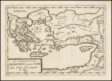
An impressive map of the Caucasus region, expanding into Tartarie in the north, Anatolia in the southwest, and Persia in the southeast. The map is superimposed on a caravan scene, showing travelers to and from a small city, with jagged mountains in the background. To supplement the view is accompanying text detailing notes on five different parts of the view. In the view, just to the right of the map and atop a mountain, lies a small engraving of what appears to be Noah's ark, which is confirmed by the text in description E.
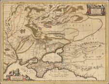
The map is attractively designed and shows a large amount of detail in the region, with French place names. Three regions within a larger Armenia are mentioned in the title: Turcomania, Georgia, and Commania. Only one of those has retained autonomy in the modern era, Georgia. Turcomania is labeled in the furthest south of this map, approximately in modern Iran. This refers to a poorly studied and little understood culture, that of the Turkmen's. Anderson and Stansfield start a chapter on this people with "Few facts about Iraq's Turkmen community are easy to establish." They refer to a dearth of maps showing Turcomania or Turkmeneli, making this a rare example to supplement the Guthrie map they cite. The region of Commania is even more difficult to chase up. There are some historical sources that suggest that this may be the classical name for Circassia. Many other regions, settlements, and features are named on the map. The mouth of the Volga is shown, as are the Black and Caspian Seas. Cities of particular importance are colored in red.
The view pictured is an intricate scene from the Caucasus. Several caravans are shown both approaching and leaving a city that lies in the midground. Several buildings in this city are labeled, including a church. In the background lies Mt. Ararat, the Turkish mountain where Noah supposedly landed after the biblical flood. Mt. Ararat is of particular importance to Armenian tradition, even appearing on the country's flag in the 19th century.
This map is very rare on the market.
Melchior Haffner is the engraver.
![Gibraltar to Berlin. [World War II Broadside Map.]](https://storage.googleapis.com/raremaps/img/small/83480.jpg)

![Europe No. 16. Partie De La Russie D'Europe [Tambow, Woroniege, Saratow and Territoire De La Milice De Don, etc.]](https://storage.googleapis.com/raremaps/img/small/19823.jpg)