|
||

|

|
|

|
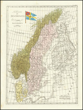
A scarce map of Norway showing its many towns, mountains, fjords, and more at the end of its two hundred and fifty year joint rule with Denmark. A cartouche is included which shows fishing vessels, a major source of income and nourishment for many Norwegians at the time.
The various provinces of Norway are all shown in outline color. This map goes as far north as Trondheim (Drontheim) at a time when the territory of Norway barely scratched the Arctic Circle. A note mentions that Salten prefecture, part of Norway at the time, can be seen on the general map of Scandinavia. Oslo is labeled Christiania.
The map shows the many fjords and islands along coastal Norway, though the aspect ratio of the country is slightly flattened. More accurate maps of Norway from continental Europe would be developed in the 19th century. In all, this is an attractive antique map of Norway with a nice cartouche.
Antonio Zatta (fl. 1757-1797) was a prominent Italian editor, cartographer, and publisher. Little is known about his life beyond his many surviving published works. It is possible that he was born as early as 1722 and lived as late as 1804. He lived in Venice and his work flourished between 1757 and 1797. He is best known for his atlas, Atlante Novissimo (1779-1785), and for his prolific output of prints and books that were both precisely made and aesthetically pleasing. Zatta clearly had a large network from which to draw information; this is how he was able to publish the first glimpse of the islands visited by Captain Cook in the Atlante Novissimo. Zatta also published books of plays and architecture.
![[Map of Sweden and Norway] Карта Швеціи и Норвегіи](https://storage.googleapis.com/raremaps/img/small/66784.jpg)
![[Southern Norway] De Zeecusten van Noorwegen tusschen Der Neus en Schuteness](https://storage.googleapis.com/raremaps/img/small/28923.jpg)