


|
||

|

|
|

|
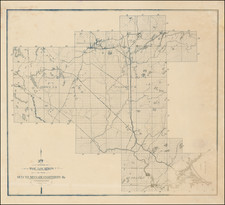
Large manuscript railway map of a section of Northeast Minneapolis (here called "East Minneapolis") directly east of the Mississippi River at Nicollet Island.
The map shows sections of the Great Northern, Wisconsin Central, and St. Paul and Duluth Railways.
On his website, John A. Week III writes about this history of the rail bridge shown at the left of this map:
The Saint Paul and Pacific Railroad built the first bridge across the Mississippi River in the Twin Cities area at this location. The bridge opened May 1, 1867. The complete river crossings consists of two spans, this bridge over the main channel of the Mississippi River, and one over the smaller east channel of the Mississippi River. The land between the two river channels is known as Nicollet Island.
The first bridge was an iron truss bridge, with the trains running through the truss span. That bridge was replaced in 1893 with a steel bridge that used the deck plate girder design. That bridge was rebuilt again in 1926. The bridge had to be modified in 1963 to support the 9-foot navigation channel project as the Upper and Lower Saint Anthony Falls Locks & Dams were set to open. Two deck plate spans and a pier were removed and replaced with a Petit style truss span. The bridge was modified once again in 1987 to accommodate the newly built West River Parkway, which passes under the west end of the bridge.
This map was first made when that bridge was built in 1893 and updated with grade crossings.
The map labels many of the buildings around the railroad and 1st Avenue Northeast to Harrison Street in the east.

![[Hastings, Minnesota]](https://storage.googleapis.com/raremaps/img/small/92128.jpg)