|
||

|

|
|

|
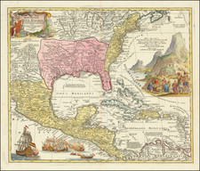
With an Extremely Late Depiction of "West Florida".
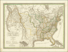
A rare map of the eastern United States, featuring three lively vignettes. The map shows the areas of the United States which have gained statehood by the time this map was published, with the exception of most of Texas and a sliver of Minnesota. The areas east of this are shown in detail, with extensive topography, rivers, cities, and more.
The three vignettes chosen to represent the eastern United States betray an interesting preconception as to what were the most important scenes regarding the area. The image of Battery Park looks very European. Importantly, this preserves an early view of the Battery and New York Harbor. The Capitol is shown as an imposing and almost cruel building standing in a grey wasteland. Niagara (also Horse Shoe Falls on the map) shows that even this most built-up area of the country has natural beauty unlike that of Europe.
Unlike this map's western counterpart, the geopolitical boundaries of this map, with few exceptions, are similar to those of today. The "Kanzas" territory and a united Virginia are perhaps the most obvious, but there is one particularly intriguing detail. "West Florida" is mapped as its own state, extending from Iola to Pensacola. The short-lived Republic of West Florida was founded in 1810 after disputes with the Spanish administration but by 1822 the two states had merged during statehood. Very few maps show West Florida, and even fewer from as late as the 1850s. It is unclear where Adlard obtained this notion of two Floridas.
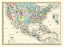
The map is reminiscent of the style of John Tallis and it is the first time we have offered this map for sale. It was published with at least one other map, United States West, which shows Texas and the various strangely shaped territories of the time, including odd New Mexico, Missouri, and Nebraska territories.
The date can be constrained to between 1846 and 1850 for this map from the absence of California in the western map, but the inclusion of Iowa.

![[Los Angeles Olympic] O Limp Hicks Loose Anglaise Calif. 1932](https://storage.googleapis.com/raremaps/img/small/90509.jpg)