


|
||

|

|
|

|
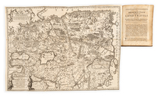
Scarce Russian Military Topographers map of the city of Pskov, issued in 1821.
The map includes a 25-item list of the streets of the city (at the right edge), a 17-item list of city gates (upper-left), and an extensive key at the bottom listing seven monasteries, cathedral, and diocesan buildings, 44 parish churches, 19 public buildings, eight parish churches (within settlements), four public buildings (within settlements), and 3 bridges.
Pskov is in the northwest of the present-day Russian Federation. It is a regional center located near the Estonian border. The city was first mentioned in 903. In the 13th-15th centuries, Pskov was a feudal republic and a member of the Hanseatic League. Along with Novgorod, the city came to epitomize Russia in the eyes of foreigners, especially in the German world. The city first appeared on a printed map in 1492 (Schedel) beating Moscow in that regard by15 years (1507). By 1510, Pskov was subordinated and incorporated into the Grand Duchy of Muscovy and was subsequently pillaged by Ivan IV (although to a lesser extent than Novgorod). It gradually lost its political and economic importance, although for some time it played a military role as a strategic vantage point between East and West.
The map itself was engraved by Cantonist Artemyev and the words were engraved by Cantonist Vetkin.
We extend our thanks to Denis Khotimsky for his help in cataloging this map.
Provenance
Ink-stamped seal of the Imperial Novorossiiskii University, Odessa. The University was founded in 1865, it was one of the top 10 universities in the Russian Empire by 1917. The Imperial University system was partially liquidated and reorganized during the Russian Revolution.
![[Napoleon]. A Sketch of the Russian Campaign in 1812](https://storage.googleapis.com/raremaps/img/small/63426.jpg)