|
||

|

|
|

|
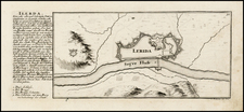
"A very rare early map of the Siege of Barcelona"
A rare map which shows the artillery and ship movements during the 1706 Siege of Barcelona. This map is of the eastern side of the city and of surrounding hills, where the battle centered. Montjuic, the elevated hill on the coast, is where most of the siege was conducted.
East Barcelona is shown in some detail on this map, with major arteries and fortifications shown. More focus is put on the surrounding topography, fields, and roads, where most of the action would have taken place.
Lines of artillery fire and bombs scattered throughout the city and fields immediately show the nature of the battle. It appears that Montjuic has already been taken by the invading force, and this strategic advantage is used to more successfully bomb the city. The walls are breached in the center of the map, and the invading army appears close to overrunning the city.
This map is very rare on the market, and it is the first time we have offered it for sale. This version is more focused on the battle than Bailleul's 1708 map, one of the few contemporary maps which also depicts this battle. The layout of the battle is very different in these two maps, perhaps reflecting the difference between Austrian and French points of view. Bailleul's map does not show the invading force as having taken Montjuic yet, and it leaves out any ships involved. There may be some question as to whether one of these maps actually depicts the 1705 invasion of the city. This map is very likely to represent the 1706 battle, not just because of the title, but also due to the flags of the invading ships.
The War of the Spanish Succession
The War of the Spanish Succession was fought from 1701 to 1714 over who would succeed Charles II. France backed a Bourbon line, Philip V, while Great Britain, Austria, and others (the "allies") supported a Hapsburg line. Many other factors also came into play, such as the control of American economic markets. Fighting occurred through Spain, the Low Countries, and Italy.
Barcelona was identified as an attractive target for the Allies from early on due to its port nature and potentially sympathetic populace. Admiral Rooke first tried to take the city from the Bourbons 1704 during the Landing at Barcelona, during which they were joined by 1,000 Catalans. However, the uprising within the city that they had hoped for did not materialize, and they retreated when French reinforcements arrived.
Despite this earlier engagement, French generals decided to reinforce Nice rather than Barcelona. Subsequently, Lord Peterborough landed on the east side of the city in 1705. This landing sparked an uprising, and Catalan rebels blocked further resupply of the city. Peterborough navigated his troops around the city to the Montjuic area, and took the area in September. The fiercer than anticipated fighting led to the death of Prince George. The city fell, and the invaders were welcomed, with little remaining sympathy for the Bourbons.
The following year, 1706, saw the battle believed to be portrayed in this map. After a blockade by the Count of Toulouse, as shown on the map, French forces navigated to try and take the city. Sources on the actual battle are rare, but if this map is to be believed, they took the fortifications at Montjuic before assaulting the city. It is accepted that they managed to breach the walls at least once, as shown on the map. However, the appearance of a fleet of English ships forced a retreat. This victory was much celebrated in England with John Friend's account of the battle and this map may have had a similar effect in Germany and Austria.
This battle was followed two weeks later by a solar eclipse seen around Europe. For the Allies, this was believed to be a symbol of the Sun King's (Louis XIV) diminishing power, while the French court saw it as a purely scientific phenomenon.
Barcelona would remain in Allied hands until 1714 and a siege which would finally turn the tide of the war. This proved a decisive victory for Philip V and the Bourbons, who eventually won the war and title of King of Spain. Barcelona retained its semi-autonomous capacity to some extent after the war, as well as its fierce sense of independence.
Mathaus Merian (1593-1650) was the father of engraver Matthäus the Younger, and of the painter, engraver, and naturalist Maria Sibylla Merian. He was born in Basel, Switzerland and trained in engraving in Zurich. After a time in Nancy, Paris and Strasbourg, he settled in Frankfurt. While there, he worked for Johann Theodor de Bry, the publisher and son of the travel writer. In 1617, he married Maria Magdalena de Bry, Johann Theodor’s daughter. In 1623, Merian took over the de Bry publishing house upon the death of his father-in-law. Merian’s best known works are detailed town views which, due to their accuracy and artistry, form a valuable record of European urban life in the first half of the sixteenth century

![Les Estats de la Couronne d'Arragon en Espagne ou sont l'Arragon Royaume, la Catalogne Princip[au]té, la Valence Royaume, et les Isles de Maiorque... 1653](https://storage.googleapis.com/raremaps/img/small/80239.jpg)