|
||

|

|
|

|
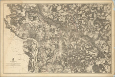
One of the earliest obtainable maps of the Carolinas.
A rare adaptation from the significantly revised second state of Morden's map of the Carolina region by Abraham Wolfgang. This map is identical to the 1687 state, with the exception of French-language title and the misspelling of Hilton Head as "Hilson Head." This second state of Morden's map that the present map is based on is nearly identical to the first state of Morden's map, with the only major alteration being the addition of Barely Count near Charles Town.
Beginning in the 1670s, the English fortunes in North America took a dramatic turn upward, resulting in a booming interest in the British American Colonies and, in turn, the issuance of maps to satisfy this interest. This map of the Carolinas first appeared in the 1680 edition of Morden's Geography Rectified with the title Carolina, Virginia, Maryland & New Jersey. A second state of the map, with a revised title (this map), was issued in Richard Blome's The Present State of His Majesty's Isles and Territories in America, published in 1687. Starting in 1688, Morden issued a revised set of maps, with the Carolinas map changed to a reduced version of Thornton, Morden & Lea's A New Map of Carolina.
While this map extends to New Jersey, the focal point of the map is the Carolinas, with latitudes to the north of Cape Henry compressed. In the second edition, there are additional revisions to the map, including the re-engraving of the Cooper River (starting further west than the first edition), and the addition of the Stone and Edisto Rivers (replacing "Lock Island" and "R. Grande").
North of Charles Town, the old Charles Town is erroneously added, as are "Watere R" and "Sante R". This erroneous depiction is likely drawn from Joel Gascoyne's map of 1682. Farther south, Edelano Island is formed at the outlet of a branch of Ashley Lake, with St. Catalina being named farther offshore.
Robert Morden (d. 1703) was a British map and globe maker. Little is known about his early life, although he was most likely apprenticed to Joseph Moxon. By 1671, Morden was working from the sign of the Atlas on Cornhill, the same address out of which Moxon had previously worked. Most famous for his English county maps, his geography texts, and his wall maps, Morden entered into many partnerships during his career, usually to finance larger publishing projects.
![A New and Exact Map of the Dominions of the King of Great Britain on ye Continent of North America . . . [Beaver map]](https://storage.googleapis.com/raremaps/img/small/101277.jpg)
![[Richmond, Virginia Imprint] Map of the State of Virginia Containing The Counties, Principal Towns, Railroads, Rivers, Canals & All Other Internal Improvements. Published by West & Johnston. Richmond Va. 1862 . . .](https://storage.googleapis.com/raremaps/img/small/35235.jpg)