|
||

|

|
|

|
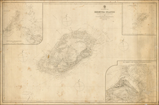
A rare separately issued chart of the Virgin Islands, first published by the British Admiralty in 1868. The map shows the Lesser Antilles from the eastern tip of Puerto Rico through the Virgin Islands and to Anguilla. In addition, an inset chart of Sombrero Island as well as coastal profile views of several of the Virgin Islands from sea are included. The charts show extensive navigational information, including soundings, tidal information, reef channels, and more.
The islands shown in this map would change hands several times through the publications of this map. Puerto Rico would become American territory after the Spanish-American War, and the Danish Virgin Islands would also become American during the 1916 Treaty of the Danish West Indies, which had been approved by Danish voters in a referendum.
The British Admiralty published some of the best available sea charts into the modern era. This can be seen in the extensive soundings and other notes that have been made. The navigability of various areas is well explained through this map. Further, the signals from lighthouses, buoys and beacons are all explained in the upper right corner. Inland areas are documented, though the focus of this map is on navigability.
Two coastal profiles show the approaches to some of the Virgin Islands. St. Thomas Harbor is shown from ten miles away, in a view that stretches from Culebra Island to Frenchman's Gap. Virgin Gorda is shown from the east, in a view stretching from Cooper Island to Necker Island. Each view shows the topography of the islands in detail, as well as providing notes on the navigability.
The early versions of this map misplaced Sombrero Island. This was rectified in a later version, and a red line from a post-1934 edition seems to have settled the matter. Notes about the lack of water and vegetation are crossed out, likely after the guano mining boom of the 1870s. This resource was depleted by 1890.
In all, this is a good quality map focusing on the Virgin Islands, remarkable for its visual simplicity while conveying extensive information.
The British Admiralty has produced nautical charts since 1795 under the auspices of the United Kingdom Hydrographic Office (HO). Its main task was to provide the Royal Navy with navigational products and service, but since 1821 it has also sold charts to the public.
In 1795, King George III appointed Alexander Dalrymple, a pedantic geographer, to consolidate, catalogue, and improve the Royal Navy’s charts. He produced the first chart as the Hydrographer to the Admiralty in 1802. Dalrymple, known for his sticky personality, served until his death in 1808, when he was succeeded by Captain Thomas Hurd. The HO has been run by naval officers ever since.
Hurd professionalized the office and increased its efficiency. He was succeeded by the Arctic explorer Captain William Parry in 1823. By 1825, the HO was offering over seven hundred charts and views for sale. Under Parry, the HO also began to participate in exploratory expeditions. The first was a joint French-Spanish-British trip to the South Atlantic, a voyage organized in part by the Royal Society of London.
In 1829, Rear-Admiral Sir Francis Beaufort was appointed Hydrographer Royal. Under his management, the HO introduced the wind force scale named for him, as well as began issuing official tide tables (1833). It was under Beaufort that HMS Beagle completed several surveying missions, including its most famous voyage commanded by Captain FitzRoy with Charles Darwin onboard. When Beaufort retired in 1855, the HO had nearly two thousand charts in its catalog.
Later in the nineteenth century, the HO supported the Challenger expedition, which is credited with helping to found the discipline of oceanography. The HO participated in the International Meridian Conference which decided on the Greenwich Meridian as the Prime Meridian. Regulation and standardization of oceanic and navigational measures continued into the twentieth century, with the HO participating at the first International Hydrographic Organization meeting in 1921.
During World War II, the HO chart making facility moved to Taunton, the first purpose-built building it ever inhabited. In 1953, the first purpose-built survey ship went to sea, the HMS Vidal. Today, there is an entire class of survey vessels that make up the Royal Navy’s Hydrographic Squadron. The HO began to computerize their charts in the late 1960s and early 1970s. In 1968, the compilation staff also came to Taunton, and the HO continues to work from there today.

![[Martinique, Guadaloupe, Dominica and Marie Galante] . Suite des Isles Antilles 2. Partie](https://storage.googleapis.com/raremaps/img/small/81614.jpg)
![Porto Rico and Virgin Islands [with] Haiti, Hispaniola or St. Domingo](https://storage.googleapis.com/raremaps/img/small/78402.jpg)