|
||

|

|
|

|
The Single Most Important Revolutionary War Chart of Narrangansett Bay -- Used by Both the British and French Navy
In support of France's new military interests in North America, George Louis Le Rouge, then mapmaker to King Louis XVI, set out to create a set of sea charts of North America for use by the French Navy. Le Rouge's Pilote Americain Septentrionale drew heavily upon the work of William Faden and Thomas Jefferys, utilizing a series of maps first published in 1775 under the title North American Pilot, which consisted of 2 volumes, one focusing on Canadian waters and the second focusing on what would become the 13 Colonies. The maps were modified with French nomenclature and sailing directions and improved where better information was available.
Because its primary purpose was as a military atlas designed for use at sea by the French Navy, very few examples of the Pilote Americain Septentrionale have survived, and even fewer in good condition The individual maps from this atlas rarely appear on the market.
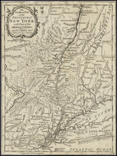
This edition was published by Le Rouge in the Pilote Americain Septentrionale in 1778. For this map, Le Rouge has combined the work of Des Barres and Blaskowitz and added an inset plan of Newport, Rhode Island. The map was almost certainly one of the primary charts utilized by Admiral D'Estaing when the French attacked Narragansett Bay in August 1778.
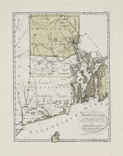
This fine plan, first published in 1777, is without question the most important eighteenth-century chart of Narraganset Bay. Nebenzahl notes that:
"it is certain that the British, after occupying Newport at the end of 1776, used this map for their operations in this pivotal area. The detail shown is remarkable, including even the names of farmers on their land locations."
The French also quickly seized upon the map when they made Newport their primary base of naval operations after joining the American cause in 1778 and published a map this same year. The Pilote Americain Septentrionale drew heavily upon the work of William Faden and Thomas Jefferys, utilizing a series of maps first published in 1775 under the title North American Pilot, which consisted of 2 volumes, one focusing on Canadian waters and the second focusing on what would become the 13 Colonies. The maps were modified with French nomenclature and sailing directions and improved where better information was available.
As the map’s title suggests, it contains military information, indicating both British and American batteries and forts throughout the area. The map also shows the location of then Brown College in Providence and provides street plans of Newport, Providence, Bristol and other cities. An inset of Newport is provided along with the area’s road system and extensive nautical information.
The map itself is unusual, in that it is a combination of a nautical chart and topographical map (and hence the English title, "A Topographical Chart..."). The Bay is clearly shown with its many islands and intricate inlets, with numerous soundings which give accurate readings of the treacherous waters. On the shore, impressive detail is depicted, with individual farms named and elegant hachuring showing elevations. Eight batteries are shown via lettered references, with a key at the top right corner which details the numbers and types of canons. Along the right side of the map are the names of the principal landowners of the region, along with a brief description of the area. A large and well-designed dedication by Faden, to Lord Percy, appears just below. The scene of tension between American and British forces since 1776, Howe would have wanted this area particularly well documented.
Charles Blaskowitz arrived in America in the early 1760s, where he began surveying work in upstate New York and along the St. Lawrence River. In March 1764, he was commissioned as part of Samuel Holland's North American Survey team and would eventually become Holland's Deputy Surveyor by 1775. Blaskowitz's first assignment was to survey Aquidneck Island and Narragansett Bay in Rhode Island, in order to determine whether Newport would be a suitable location for a naval base. Blaskowitz completed this survey in 1764 and later re-surveyed the region as part of Holland's larger surveys of the coast in 1774, for the Board on Trade and Plantations.
Blaskowitz's surveys would be used for two printed charts, by Des Barres and Faden, respectively. The Faden chart was a much more accomplished production, on a larger sheet and more elaborately engraved (and according to Pedley, costing two and a half times as much at the time of publication). The map was sold separately or within some copies of Faden's North American Atlas.
The colonies were already on the brink of revolution and Newport was a hotbed of insurrection even predating the Revolution. In 1772, British naval ships laid siege to Narragansett Bay, in order to enforce customs duties on incoming vessels. After months of antagonizing the city's merchants, the much-hated British captain of the HMS Gaspee was injured and the ship burned. Lt. Dudingston, captain of HMS Gaspee, was treated by one of the attackers before he was taken off the ship. He was then delivered to a nearby physician for further treatment. Dudingston lived until 1817.
The region instantly became a point of great interest in Great Britain, with the King offering a reward for the capture of the insurrectionists. In May 1776, Rhode Island became the first Colony to declare its independence and the British would occupy Newport from November of 1776, until the end of August 1778.
The Battle of Newport
Sometimes called the Battle of Rhode Island, the Battle of Newport marked the entry of the French forces into the war and a turning point for the Revolution. General Lafayette claimed this was the best-fought battle of the war.
Following the commencement of the American Revolution, France initially played a passive support role on behalf of the American colonist. While some French important French officers, including Lafayette and Pierre L'Enfant joined the Americans as volunteers, for the first two years, the French primarily provided military and other supplies to the Americans. Ultimately, in 1778, following several years of diplomatic efforts by Benjamin Franklin and others, France formally recognized the United States on February 6, 1778, which was followed shortly thereafter by Britain's declaration of war on France on March 17, 1778.
When the French Navy joined the war, American forces had been at a standoff against Aquidneck Island [formally Rhode Island, labeled as such on the map] since 1776. British troops held the island and the city of Newport, while American troops were stationed on the mainland. Washington had wanted the island attacked as early as 1777, but Major General Spencer, commander of the troops in the region, had refused to do so resulting in his removal from command.
The arrival of French troops and ships into the battle rejuvenated the cause for attacking the island. General Sullivan, now in charge of the American forces, had put out a call to raise more troops. Militias from all over Rhode Island and New England joined, increasing his forces. In anticipation, British forces removed their troops from Butts Island (just inland of Black Point on the map) and Conanicutt Island (across the bay from Aquidneck) and withdrew to Newport.
French troops initially landed at Conanicutt, where they planned to launch an attack on Newport. However, General Howe arrived to defend the city. D'Estaing withdrew his troops to fight Howe at sea, however a storm badly destroyed both fleets and they had to withdraw. After both fleets left, more British forces threatened to arrive, placing Sullivan in a precarious position.
Sullivan had already taken Butts Hill after it was abandoned by the British. However, the news of the French withdrawal worried his supporters and many abandoned the fight. With the risk of more troops arriving, Sullivan decided to launch an immediate attack. Sullivan marched down the eastern road shown on the map to the next hill to the south, Quaker Hill. Meanwhile, Hessian troops marched north along the western road shown to Turkey Hill. The Americans came under fire but managed to hold their position. However, after more British troops arrived and they became outflanked they had to retreat. Eventual fighting managed to push the Hessians back to Turkey Hill, however artillery fire from a British frigate limited further movement.
The American forces retreated to the mainland near Bristol [labeled Bristol Neck on the map] in an unhurried and orderly fashion. Neither side sustained many casualties, nor were there any major strategic changes, but this represented the beginning of French and American collaboration which would eventually help win the war.
George-Louis Le Rouge (1712-1790), though known for his work in Paris, was originally born Georg Ludwig of Hanover, Germany. He grew up and was educated in Hanover, after which he became a surveyor and military engineer. Around 1740, however, Le Rouge moved to Paris and set up shop as an engraver and publisher on the Rue des Grands Augustins. It was at this time that he changed his name, adopting a French pseudonym that would later become quite famous.
Le Rouge spent much of his forty-year career translating various works from English to French, and his cartographic influence often came from English maps. His experience as a surveyor and engineer in Germany made him a skilled and prolific cartographer, and he produced thousands of charts, maps, atlases, and plans. His work spans from garden views and small-town plans to huge, multiple-continent maps. Le Rouge eventually accepted the position of Geographical Engineer for Louid XV, the King of France.
Later in life, Le Rouge became well-known for publishing North American maps, such as in his Atlas ameriquain septentrional of 1778. One of Le Rouge’s other more famous works is the Franklin/Folger chart of the Gulf Stream, which he worked on with Benjamin Franklin. Franklin and Le Rouge corresponded around 1780 and collaborated to create this map, a French version of Franklin’s famous chart which was originally printed in 1769.
![(Rhode Island Coastal Defenses) [9 Engineering Plans for Barbette Batteries and Related Fortifications]](https://storage.googleapis.com/raremaps/img/small/92401.jpg)
![[ Yorktown ] Plan of the Siege of York Town in Virginia . . .](https://storage.googleapis.com/raremaps/img/small/102061.jpg)