


|
||

|

|
|

|
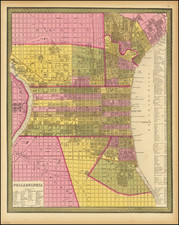
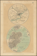
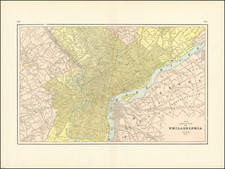
A rare map of Philadelphia and Boston, from Rogers & Johnston's Atlas of the United States. The map shows the layout of the two cities including streets, neighborhoods, and other major features. The map of Boston and environs only shows the downtown area, Charlestown, East Boston, and South Boston, an area only several miles across centered on Boston Harbor. The map of Philadelphia, on the other hand, is tens of miles across. While the city was significantly more populous than Boston, such a wide portrayal was likely unnecessary. However, this allows for good detail on the areas that now encompass the suburbs and neighboring cities of Philadelphia.
The choice of these two maps is puzzling; it is unlikely that they were ordered alphabetically or by founding date. Whatever the reasons Rogers and Johnston may have had, these are two cities at the center of the Revolutionary War shown on a single mid-19th century sheet.
![[ Boston Light ] A South West View of the Lighthouse. Situate at the Entrance of Boston Harbour.](https://storage.googleapis.com/raremaps/img/small/97747.jpg)
![[Cape Cod area / Nantucket / Martha's Vineyard / Boston Bay]. (Revolutionary War Era Manuscript Sea Chart)](https://storage.googleapis.com/raremaps/img/small/69611.jpg)