|
||

|

|
|

|
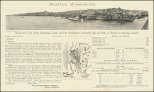
The First Printed Bird's-eye View of Seattle
Rare early view of Seattle, published by E.S. Glover
The view shows Seattle from the waterfront, at a time when its total population was less than 3,000 people. Streets are named, as are the wharves, with a reference key noting 20 points of interest.
As noted on the Washington University Library website:
The first known map of Seattle was created in 1854 by a U.S. navy crew. It was not until 1878, when E.S. Glover drew a “bird’s-eye view” of the city that Seattle was mapped again. Glover began his technique by drawing a layout of the city’s “topography and streets.” He then chose a viewpoint and began sketching major landmarks on the street such as buildings and docks. At the time that Glover drew this map, Seattle contained only about 3000 residents with a heavy lumber industry and an assortment of mudflats in the south. Of note, the business district depicted takes up only 6 blocks (Anderson).
Seattle
The founding of Seattle dates back to the arrival of the Denny Party on November 13, 1851, at Alki Point. The party had traveled from the Midwest to Portland, Oregon, then up the Pacific coast into Puget Sound, with the express intent of founding a town. The following April, Arthur A. Denny abandoned the original site at Alki in favor of a better-protected site on Elliott Bay, near the south end of what is now downtown Seattle. Around the same time, Doc Maynard began settling the land immediately south of Denny's townsite. The first plats for Seattle were filed on May 23, 1853.
Nominal legal land settlement was provisionally established in 1855 (with treaty terms for what is now Seattle not implemented). Doc Maynard's land claim lay south of today's Yesler Way, encompassing most of today's Pioneer Square Historical District and the International District. He based his street grid on strict compass bearings. The more northerly plats of Arthur A. Denny and Carson D. Boren encompassed Pioneer Square north of what is now Yesler Way; the heart of the current downtown; and the western slope of First Hill. These had street grids that more or less followed the shoreline. The downtown grid from Yesler Way north to Stewart Street is oriented 32 degrees west of north; from Stewart north to Denny Way the orientation is 49 degrees west of north. The result is a tangle of streets where the grids clash.
Seattle and Alki would grow as competing cities, although in the early days, there were less than 8 blocks of flat usable land in Seattle. However, the arrival of Henry Yesler and his establishment of a lumber mill between the Denny and Maynard grids established Seattle as the primary hub in the area.
The town would grow slowly for the next 20 years. On July 14, 1873, the Northern Pacific Railway selected Tacoma over Seattle as the Western terminus of their transcontinental railroad. The railroad barons appear to have been gambling on the advantage they could gain from being able to buy up the land around their terminus cheaply instead of bringing the railroad into a more established Pacific port town.
The citizens of Seattle chartered their own railroad, the Seattle & Walla Walla, to link with the Union Pacific Railroad in eastern Washington. The S&WW never got beyond Renton, but that was far enough to connect with new coal mines, fueling industry in Seattle.
By 1878, Seattle's population was probably close to 3,000 people. It grew quickly from only 1,151 in 1870 to 3,533 in 1880. But in the 1880s the population exploded, reaching 42,837 in 1890.
Rarity
The view is extremely rare. We were unable to locate any examples at auction or in dealer catalogs.
OCLC locates copies at the Library of Congress, Amon Carter Museum and Bancroft Library. We also note a copy at the University of Washington.
This is the second example of the view we have offered for sale.
Eli Sheldon Glover (1844-1920) was one of the great viewmakers of the golden age of American bird's eye views. He began his career working for Albert Ruger in Ypsilanti, Michigan in 1866. He was primarily a sales agent for Ruger but probably also helped him in the actual production of city views. Two years later Glover went to Chicago to become a printer and publisher under his own name, but his Merchants Lithographing Company was shortlived; it was destroyed by the 1871 Chicago Fire after only three years of operation. The Great Fire caused Glover to look farther afield, and he began making views in Ontario and Kansas. Slowly he made his way west, producing Colorado views in 1873-'74. In 1874, while based in Salt Lake City he traveled the Rocky Mountains and produced views in Montana, Utah, and Wyoming. In 1876 and '77, the Glovers lived in Los Angeles and Eli produced a total of 16 views of California cities. In the last period of his active career, he focused on views in Oregon, Washington, and British Columbia. His second to last view was in Alabama, and his final view, in 1912 after a long hiatus, was Port Arthur, Texas.

![(Canadian-American Boundary) [Group of 11 photographs by Alexander Gardner, including 3 after the British Commission's 1860-61 photographs, for the North American Boundary Commission Survey along the 49th Parallel, used in settling Hudson's Bay Co. claims in the British and American Joint Commission]](https://storage.googleapis.com/raremaps/img/small/95481.jpg)