


|
||

|

|
|

|
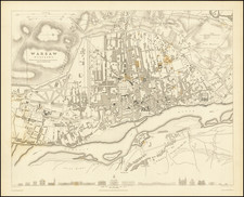
A highly detailed town plan of Warsaw which includes profile views of 16 major buildings across the bottom of the map. This forms part of the first edition of the best published commercial atlases of the 19th century.
This map was published during the end of a brief period of autonomy that had existed since liberation by Napoleon. The Polish-Russian War of 1831 lead to increased control from Russia. A major event in this war was the burning of Praga in 1831, noted on the map. The period during Russian rule would see the arrival of the railways and industrialization. The first steps of modernization are already preserved in this map, such as the Royal University (now Warsaw University) built in 1816, shown but unlabelled.
The map preserves the layout of the city during the rapid expansion in the late 19th century and during the Soviet era. More importantly, Old Warsaw is shown as it stood prior to World War II, when over 85% of the city was destroyed. Nearly all of the buildings shown in profile did not survive the war and only some rebuilt. The Church of the Holy Cross, final resting place of Chopin's heart, is presented with its baroque facade as it predates the war.
![[ Warsaw to Krakow ] Der Koniglichen Republik Polen Woiwodschaften Krakuw u Sanomir mit dem untern Teile der Woiwodschaft Lublin undd dem Herzogthme Severein oder Klein Polen westlicher Theil . . .](https://storage.googleapis.com/raremaps/img/small/103028.jpg)
![[Poland, Lithuania, Russia, Ukraine, Romania] Eur. VIII Tab:](https://storage.googleapis.com/raremaps/img/small/89171.jpg)
![Hanc Ger[maniae et P]oloniae de[s ... ]em Serenissim [P]otentissimi Poloniae Regi August offert et inscribit Petrus Schenck](https://storage.googleapis.com/raremaps/img/small/64898.jpg)