


|
||

|

|
|

|
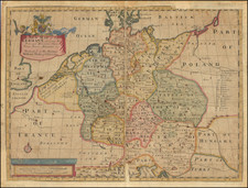
A striking map of Western Germany, published by John Arrowsmith. This area had been one of the most stable in Europe and was comprised of the confederation of states as shown on the map. The map shows only states in the western part of Germany, omitting most of the Prussian heartland. The map shows Hanover, Holstein, Brandenburg, Bohemia, Bavaria, the Kingdom of Saxony and many other states comprising the confederation. Small Prussian enclaves dot the map. The relative stability of this period would be punctuated six years after the publication of this map with the 1848 uprisings. These ill-fated revolutions which centered in the western regions of Germany, notably in Bavaria and Baden, would only lead to reactionary governance in an attempt to stymie further liberal tendencies.
This map is well designed and contains extensive information and detail, typical of Arrowsmith's maps. In all, it is a clear map of Western Germany from the mid-19th century, showing an area which was on the brink of revolution.
The map appeared in John Arrowsmith's London Atlas.
The Arrowsmiths were a cartographic dynasty which operated from the late-eighteenth century to the mid-nineteenth. The family business was founded by Aaron Arrowsmith (1750-1823), who was renowned for carefully prepared and meticulously updated maps, globes, and charts. He created many maps that covered multiple sheets and which were massive in total size. His spare yet exacting style was recognized around the world and mapmakers from other countries, especially the young country of the United States, sought his maps and charts as exemplars for their own work.
Aaron Arrowsmith was born in County Durham in 1750. He came to London for work around 1770, where he found employment as a surveyor for the city’s mapmakers. By 1790, he had set up his own shop which specialized in general charts. Arrowsmith had five premises in his career, most of which were located on or near Soho Square, a neighborhood the led him to rub shoulders with the likes of Joseph Banks, the naturalist, and Matthew Flinders, the hydrographer.
Through his business ties and employment at the Hydrographic Office, Arrowsmith made other important relationships with Alexander Dalrymple, the Hudson’s Bay Company, and others entities. In 1810 he became Hydrographer to the Prince of Wales and, in 1820, Hydrographer to the King.
Aaron Arrowsmith died in 1823, whereby the business and title of Hydrographer to the King passed to his sons, Aaron and Samuel, and, later, his nephew, John. Aaron Jr. (1802-1854) was a founder member of the Royal Geographical Society (RGS) and left the family business in 1832; instead, he enrolled at Oxford to study to become a minister. Samuel (1805-1839) joined Aaron as a partner in the business and they traded together until Aaron left for the ministry. Samuel died at age 34 in 1839; his brother presided over his funeral. The remaining stock and copper plates were bought at auction by John Arrowsmith, their cousin.
John (1790-1873) operated his own independent business after his uncle, Aaron Arrowsmith Sr., died. After 1839, John moved into the Soho premises of his uncle and cousins. John enjoyed considerable recognition in the geography and exploration community. Like Aaron Jr., John was a founder member of the RGS and would serve as its unofficial cartographer for 43 years. Several geographical features in Australia and Canada are named after him. He carried the title Hydrographer to Queen Victoria. He died in 1873 and the majority of his stock was eventually bought by Edward Stanford, who co-founded Stanford’s map shop, which is still open in Covent Garden, London today.
![[ Germany -- Embellished with Animals ] Tabula Europae IIII](https://storage.googleapis.com/raremaps/img/small/100690.jpg)
![[ Postal Map of Eastern Europe ] Deutschlands Postkarte begraenzt von Oesterrreich, Preussen, Frankreich, Holland, Italien und der Schweiz. Gezeichnet und Herausgegeben von Ignaz Heymann. K.K. Obserpostamtsoffizier in Trieste. 1800.](https://storage.googleapis.com/raremaps/img/small/77678.jpg)