|
||

|

|
|

|
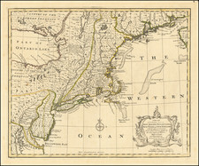
One of the Rarest and Most Attractive 18th-century American City Plans.
A superb and extremely rare 18th-century American city plan laid down by two French savants, Pierre Pharoux the architect, and Charles Saint-Memin the engraver.
The city of Esperanza (sometimes called Speranza) was a planned city intended to serve as the main port on the west side of the Hudson River for goods coming from western New York and points beyond. The city was a speculative venture of members of the Livingston family, the most powerful landowners in New York State at the time. It was never as successful as the investors had hoped but eventually became what is now Athens, New York.
The city is laid out on a pleasing, rational grid and is organized around a market square (closest to the river), a church square, and a courthouse square, with public parks and common grounds emanating from the courthouse in a radial fashion. The city seems to be appended to a pre-existing community with buildings already built, along Loonenberg Street and Water Street. At least on paper, the town of Esperanza has the makings of a bustling river port, with a large key "Esperanza Key", wharves, a shipyard, city tavern, multiple churches, and a courthouse.
This map was used in tracking original land sales or divisions, as plots are marked with owners' initials in an early hand.
The execution of the map is quite impressive and evinces artistry surpassing that of other American engravings of the 18th century.
Pierre Pharoux
Pierre Pharoux was a classically-trained French architect who fled to North America during the French Revolution.
Pharoux arrived in Albany in the fall of 1793. He had traveled there to survey the area between the Adirondacks and Lake Ontario known as Castorland. He took on private clients while there as well - his Continental skills brought a much-desired flair to the architecture of the Hudson Valley and he received numerous commissions from the area's wealthiest residents. In a 59-page sketchbook (now held at the Huntington), he drew many designs for houses, industrial and agricultural buildings, and gardens, as well as some real and fantastical designs from Albany itself.
Prior to embarking on his surveying expedition in October of 1793, Pharoux had contact with Simeon De Witt, New York's Surveyor General.
Among the Huntington's drawings by Pharoux is "a plan of Esperanza Town on the North River".
Tragically, Pharoux's career was cut short, when in the fall of 1795, he drowned in a river while on a survey.
Charles Saint-Mémin
Charles Balthazar Julien Févret de Saint-Mémin (1770-1852) was a portraitist, sometimes engraver, and museum director, who fled France during the French Revolution and settled in the United States. Saint-Mémin drew some of the best portraits of the early Federal Period, including renderings of George Washington, Thomas Jefferson, Meriwether Lewis, and a host of Osage warriors and leaders. In most of his portraits, the subject is drawn in profile, with the physiognotrace method.
Saint-Mémin arrived in New York City in 1793, and having lost everything in the Revolution he found himself needing to work to earn a living. He quickly found jobs with the Livingston family. John R. Livingston offered both him and his father a place to stay, and it is through this connection that Saint-Mémin was attached to the Esperanza project.
Livingston Family Involvement
The Livingston family of New York was one of, if not the most important families in the Thirteen Colonies and the early United States. They had arrived in New York in the 17th century from Scotland by way of the Dutch Republic.
The speculation at Esperanza was led by Edward Livingston, who was joined by John R. Livingston, and Brockholst Livingston.
Reps
John Reps discusses the plan in his The Making of Urban America: A History of City Planning in the United States, "Backwoods Baroque":
Two other eighteenth-century and one slightly later town promotion are worth brief consideration. All exhibit some of the fanciful design elements that entered into many of the speculative town projects of this era. The first of these was literally a city built on hope, since nothing but its name, Esperanza, survives. Esperanza was founded by a distinguished group of New Yorkers headed by Edward Livingston, whose career later included service as a congressman, mayor of New York, senator from Louisiana, U.S. Secretary of State, and finally minister to France. The site of this extraordinary community was on the west bank of the Hudson almost directly opposite the thriving east-bank community bearing the name of that river.
Hudson's rival-to-be was intended to tap the trade from the western part of the state, first by a land route and ultimately by a canal. The proprietors hoped that eventually the capitol would be moved to their city. Land was purchased in 1794, and, shortly after, the plan shown in Figure 208 [actually a later facsimile drawing of the map offered here] was prepared and circulated to prospective settlers...
The street pattern and the names given the streets are curious. Liberty and Equality Streets suggest influence of the late French Revolution, and the portion of the town to the northwest, with its circular and radial boulevards, also calls to mind the grand plan of a French hunting park or the grounds of a royal chateau. Of course, this was the time when the new Washington plan was widely circulated and well known. There were other interesting paired streets: Love and Happiness; Beer and Cider; Meal and Bread; Art and Science; Wheat and Rice, with Corn, in addition. With squares for a market, churches, court house, and with reserved common land and sites for "groves," Esperanza seemingly was equipped for any eventuality. But despite the prediction that "...this infant town, will beyond all doubt, experience a considerable increase..." Esperanza, like other hopes, failed to materialize. As late as 1867 a map of the township in which it was located showed the paper streets and squares in all their elegance, but this was probably the last monument to a speculation that had failed.
Rarity
The map is extremely rare. We cannot find any copies of this map in OCLC (though two reproductions are noted) nor can we find any examples having sold either through RBH or OldMaps.com.
Provenance
Docketed on verso: "Caleb Coffin | This map was presented to Abraham Reynolds by E. Heart,"
The map shows numerous plots marked "B" or "BL" (i.e., Brockholst Livingston) and "JRL" (i.e., John R. Livingston) in ink in an early, surely contemporary, hand.