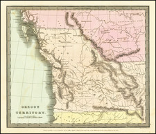
|
||

|

|
|

|
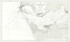
A Coast Survey map of Washington Sound, showing coastal towns, different geomorphological features, and soundings. The area is no longer known as the "Washington Sound" with the region presently described by its constituent basins, namely the Juan de Fuca Strait and the Strait of Georgia. The main map shows Vancouver Island, the mainland, as well as the many islands of the Juan de Fuca Strait. Much of the area is yet unsettled, with the coastlines showing only the occasional mine, village, or Native American settlement.
The map names all of the islands in the San Juan archipelago including Orcas and "Bellevue or San Juan I." where the tallest peak is shown at 1070 feet and "H.B. Co. Fishing Station" is located.
Includes an inset map of Admiralty Inlet and Puget Sound. Admiralty Inlet is marked much further south, in the area presently considered Puget Sound. Seattle is marked on the inset, and detail is given to the many bays and channels of the area.
The map includes a detailed chart and accompanying notes regarding the tides in the region.
Overall, an attractive coastal survey showing an area that has been heavily altered over the last century and a half, making this a key map for anyone interested in the history of the region.
![[Seattle and Vicinity] Seeing Seattle by Water - Anderson Water Tours](https://storage.googleapis.com/raremaps/img/small/77606.jpg)