|
||

|

|
|

|
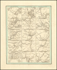
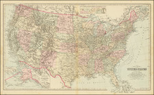
Illustrating The Rising Power of the Slave Holding States
Map Portion of Reynolds rare broadside map of the United States, published to promote the candidacy of John Fremont for President.
Reynolds fact tables, headed “Freedom vs. Slavery,” demonstrates the North’s economic and cultural superiority over slave states in terms of everything from population per square mile, capital in manufactures, miles of railroad, the number of newspapers and public libraries, and value of churches.
The map was published in the wake of the passage of the 1854 Kansas-Nebraska Act, which established two new territories and repealed the Missouri Compromise of 1820. which prohibited slavery in the Louisiana Purchase north of 36° 30’. The Act instead allows the question of slavery to be resolved locally. The resulting furor set the path to civil war and launched what would come to be called “Bloody Kansas.” National politics were thereafter domininated by the differing interests of the North and South. the end of the Whig Party and birth of the Republican Party, which in June 1856 nominated John C. Fremont as its first Presidential candidate, promoting a strident anti-slavery platform.
As noted in the description of the example in the The P.J. Mode Collection at Cornell University:
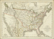
This landmark map supporting the candidacy of John Fremont played an important role in the 1856 Presidential election. It set out dramatically the stakes involved in the potential spread of slavery to the Western states, as stated in the legend below Texas: "N.B. - By the Democratic (!) legislation of 1854, repealing the Missouri Compromise, the institution of slavery may be carried into ALL the Territories - the area of which is greater than the area of all the States combined."
The 1856 campaign was dominated by the question of whether or not to repeal the Kansas-Nebraska Act of 1854, which allowed new states the option to permit slavery. The Democratic candidate, James Buchanan, supported the Kansas-Nebraska Act. John C. Fremont, candidate of the new Republican party, opposed the Act, and maps like this one were an iconic feature of his campaign literature throughout (Schulten 2012, 129-130), appearing in posters, handbills, pamphlets and the candidate's official campaign biography. The collection includes six examples of the Fremont campaign map, all dated 1856: ID #2132 (the Reynolds map poster), ID #1058 (handbill with map), ID #1059 (folding map in German), ID #2101 (pamphlet with map), ID #2199 (pamphlet with map), and ID #2264 (biography with map).
The map "startles the reader" (Schulten 129), in part through a number of techniques found in persuasive cartography. The color of the western territories differs dramatically from the pink of the free states, giving the impression that slavery has already (or nearly) arrived in the west. The text on the map describes the existing unfairness of congressional representation and postal expenditures, both favoring the slave states. And the map is not based on the familiar Mercator projection; the meridians converge to the north, suggesting a Sinusoidal or Azimuthal/Orthographic projection. See Snyder 1989. As a result, the relative size of the northern states is reduced and that of the southern states is increased, as if the globe is being viewed from above the southern states, foreshortening the northern ones.
Reynolds promoted the map for sale in the July 11 1856 New York Tribune as follows:
Now Ready:
REYNOLDS’S POLITICAL MAP OF THE UNITED STATES“-Size 29 by 31 inches.-Showing at a glance the whole country from the Atlantic to the Pacific coast; colored so as to designate the Free and Slave States; also the vast Territory which lies open to Freedom or Slavery. It also presents a vast amount of statistical matter, showing the advantage of Freedom over Slavery, together with Portraits of Fremont and Dayton.
Offered here is the map only, lacking the title and portraits of Fremont and his vice presidential candidate, but still offering this exceptional graphic illustrating the rising threat of slaveholder states to the Union and the balance of power in the United States.
Rarity
The map was issued both in sheet form for 25 cents and as a pocket map for 50 cents. There are at least two states of this map, the other lacking the additional imprint of Rufus Blanchard. The map is rare in the trade with Antique Map Price Record and Rare Book Hub listing a total of three examples having appeared on the market.