|
||

|

|
|

|
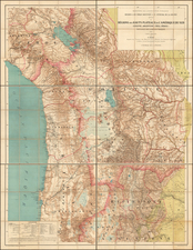
Finely executed Sea Chart of the Straits of Magellan, published by the British Admiralty.
The chart is based upon a series of 19th Century surveys, with major corrections in 1898, 1906, 1915 and 1921 and smaller corrections up to 1923.
The map includes a list of 4 major surveys which contributed to the primary mapping of the region, including:
- H.M.S. Adventure and H.M.S. Beagle, 1826-1830
- H.M.S. Nassau, 1867-68
- H.M.S. Alert, 1880
- H.M.S. Sylvia, 1882-84
The following is a summary of the earliest surveys and surveyors.
The First Surveying Voyage to Tierra del Fuego, 1826-30
Finding a safe passage around the southern tip of South America was one of the great imperatives of global shipping. Rounding Cape Horn itself was always fearsome, and while the Strait of Magellan held out the promise of a more sheltered route, its labyrinthine passages were not sufficiently understood. While the Strait itself had been surveyed in a cursory fashion by Captain James Cook, a far more exacting survey, employing the latest equipment was in order.
In 1826, the Royal Navy dispatched the HMS Adventure and its smaller companion, the HMS Beagle, to survey the coasts of southern Patagonia, and the Strait of Magellan in particular. The Beagle was commanded initially by Captain Pringle Stokes, while the overall command of the voyage fell under Captain Phillip Parker King, aboard the Adventure. The relatively nimble Beagle was charged with the far more treacherous aspects of the survey, essentially circumnavigating Tierra del Fuego. Highly advanced trigonometric surveys of the shorelines were conducted with theodolites, while copious soundings of the seafloor were taken, and navigational hazards noted. During this survey the Beagle Channel, the interoceanic passage that ran between Tierra del Fuego and Navarino Island, was discovered.
The voyage was not without mishap, however, as Captain Stokes committed suicide, only to be replaced by the energetic Lieutenant Robert FitzRoy. While only 23 years old, he proved to be a highly competent surveyor and leader. Towards the end of the voyage, a group of native Fuegians stole one of the Beagle's tenders. In response, FitzRoy took some Fuegians hostage, and while the situation was eventually diffused, it made for an unusually melodramatic surveying expedition.
Upon the Beagle and Adventure's return to England a chart was apparently published depicting the survey's findings. However, no chart of this description is known to survive, and the only record we can find of the chart is in The Nautical Magazine (London, June 1832).
The Second Surveying Voyage to Tierra del Fuego, including Charles Darwin, 1831-6
While the Admiralty was highly impressed with the surveys thus far, the project was far from complete. At FitzRoy's behest, the Beagle was dramatically retrofitted and kitted out with the most advanced scientific and navigational equipment. It also occurred to FitzRoy that while he and his men performed hydrographic surveys, someone should conduct a scientific appraisal of the land itself should be undertaken. Through an unlikely chain of inquiries they selected Charles Darwin, a brilliant but obscure amateur naturalist, who was otherwise on track to becoming a rural clergyman.
The second surveying voyage of the Beagle departed England in December 1831. Over a two-year period FitzRoy and his crew painstaking completed their surveying mandate, while Darwin combed the barren landscape "geologizing". Prefiguring the ingenious insights that would later make him famous, Darwin made highly important observations with respect to the geology, biology and anthropology of this mysterious land and its inhabitants. Once the surveying mandate was complete, the Beagle headed across the vast expanse of the Pacific, giving Darwin his first exposure to the unique flora and fauna of New Zealand and Australia. The expedition returned to England in October 1836, and the chart that was the antecedent of the present chart was published in the early months of 1837.
Darwin published his intellectually brilliant and highly entertaining account of the voyage as his 'Journal & Remarks', the third volume of FitzRoy & Darwin's Narrative of the surveying voyages of his Majesty's ships Adventure and Beagles between the years 1826 and 1836 (1839), which was subsequently popularized as the Voyage of the Beagle. His account became a best seller, and established his celebrity as a naturalist.
The Third Surveying Voyage to the Straits of Magellan, by Captain Mayne, 1866-9
A generation after King and FitzRoy's surveys, the Admiralty decided that it required more detailed bathymetric soundings in the eastern part of the Straits and further exploration of the fjords on the western side of the passage. In 1866, they selected the Captain Richard Charles Mayne to lead the endeavor. Mayne was uniquely qualified, having previously surveyed the heavily indented and mountainous coastlines of British Columbia, an area that bore geographic similarity to the southern reaches of Patagonia.
Upon hearing of the Mayne's assignment, Charles Darwin requested that the Admiralty instruct Mayne to collect fossil bones of extinct species that were known to be found along the shorelines of Tierra de Fuego. While Darwin himself had collected fossils on these shores decades previously, since then Admiral Sir Bartholomew Sulivan had discovered bones that were far more significant specimens, and belonged to a more ancient era than Darwin's finds. Mayne showed great enthusiasm for this aspect of his mandate, and one of Darwin's protégés, Robert Oliver Cunningham, was assigned to join the mission.
From 1866 to 1869, Mayne's crew, aboard the HMS Nassau, exactingly charted the waters of the Straits of Magellan. The present 1871 chart of the straits, in comparison to its 1837 predecessor, features far more copious soundings in the critical eastern passage of the strait, as well as more refined shoreline conventions throughout the waters. An inscription, which appears in the upper left center of the chart, notes that Mayne also conducted new and important surveys of the Smyth Channel area, near where the straits enter the Pacific.
Mayne's mission was considered a great all-around success. Upon his return to London, he produced this chart that would become the definitive map of the Straits for the coming decades. Consequentially, the bones and fossils collected by Cunningham and Mayne were instrumental in refining Darwin's theories on evolution. These specimens are now preserved at the Museum of Natural History in London.
Robert Charles Mayne (1835-1892) was one of the most important British hydrographers working in the Pacific in the mid-19th century. He came from a family of distinguished jurists and law-enforcement officers, and his father was the first commissioner of the London's Metropolitan Police. He joined the Royal Navy at a young age and received advanced training in hydrographic surveying. From 1856-60, Mayne conducted the first systematic coastal survey of Vancouver Island and parts of British Columbia's mainland. His charts were widely admired and his book, Four Years in British Columbia and Vancouver Island (1862), is considered a classic source on the early history of the colony. In 1862, Mayne was promoted to command the HMS Eclipse, which participated in the native wars in New Zealand. Severely wounded in battle, he was sent back to England to recuperate. Upon his recovery, in 1866, he was selected by the Admiralty to lead a high-profile mission to map and explore the natural history of the Straits of Magellan region, resulting in the present chart. Mayne was eventually promoted to Admiral, and towards the end of his life, served as an MP for the Welsh constituency of Pembroke.
Charles Darwin (1809-1882) was history's greatest and most celebrated naturalist. He is most famous for his work On the Origins of Species (1859), in which he articulated the theory of evolution. While this revolutionary concept was highly controversial at the time, it has since acquired definitive scientific authority. While his participation on the Second Tierra del Fuego expedition of the Beagle set him on a course to fame, he developed his groundbreaking theories while studying the exotic wildlife on the Galapagos Islands. His engaging style of prose and his extraordinary subject matter was instrumental in popularizing the genre of scientific writing for a broader audience.
Robert FitzRoy (1805-1865) was a navigator, meteorologist and Colonial Governor of New Zealand. He began his command of the Beagle in 1828, at the commencement of its surveying work in Patagonia, Tierra del Fuego and the Straits of Magellan. The first survey concluded in 1830, with a second survey commenced in December 1831 and was completed in 1836. The voyage's interest was increased by the presence of Charles Darwin as naturalist, with whom FitzRoy collaborated in the Narrative of the Surveying Voyages of HM Ships Adventure and Beagle, FitzRoy being responsible for the first two volumes and Darwin for the third. In 1837, FitzRoy was awarded the Gold Medal of the Royal Geographical Society for his achievements.
Philip Parker King (1791-1856) was a noted early explorer of the Coasts of Australia and Patagonia. Between 1817 and 1822, King surveyed parts of the Australian coast not already examined by Matthew Flinders, In this work, he was at various times joined by John Septimus Roe and John Oxley. In his next major assignment, he was given command of the survey vessel HMS Adventure, and in company with HMS Beagle, spent five years surveying the complex coasts around the Strait of Magellan. The result was presented at a meeting of the Royal Geographical Society in 1831, which brought King great acclaim for his accomplishments in the scientific effort to chart the Strait.
The British Admiralty has produced nautical charts since 1795 under the auspices of the United Kingdom Hydrographic Office (HO). Its main task was to provide the Royal Navy with navigational products and service, but since 1821 it has also sold charts to the public.
In 1795, King George III appointed Alexander Dalrymple, a pedantic geographer, to consolidate, catalogue, and improve the Royal Navy’s charts. He produced the first chart as the Hydrographer to the Admiralty in 1802. Dalrymple, known for his sticky personality, served until his death in 1808, when he was succeeded by Captain Thomas Hurd. The HO has been run by naval officers ever since.
Hurd professionalized the office and increased its efficiency. He was succeeded by the Arctic explorer Captain William Parry in 1823. By 1825, the HO was offering over seven hundred charts and views for sale. Under Parry, the HO also began to participate in exploratory expeditions. The first was a joint French-Spanish-British trip to the South Atlantic, a voyage organized in part by the Royal Society of London.
In 1829, Rear-Admiral Sir Francis Beaufort was appointed Hydrographer Royal. Under his management, the HO introduced the wind force scale named for him, as well as began issuing official tide tables (1833). It was under Beaufort that HMS Beagle completed several surveying missions, including its most famous voyage commanded by Captain FitzRoy with Charles Darwin onboard. When Beaufort retired in 1855, the HO had nearly two thousand charts in its catalog.
Later in the nineteenth century, the HO supported the Challenger expedition, which is credited with helping to found the discipline of oceanography. The HO participated in the International Meridian Conference which decided on the Greenwich Meridian as the Prime Meridian. Regulation and standardization of oceanic and navigational measures continued into the twentieth century, with the HO participating at the first International Hydrographic Organization meeting in 1921.
During World War II, the HO chart making facility moved to Taunton, the first purpose-built building it ever inhabited. In 1953, the first purpose-built survey ship went to sea, the HMS Vidal. Today, there is an entire class of survey vessels that make up the Royal Navy’s Hydrographic Squadron. The HO began to computerize their charts in the late 1960s and early 1970s. In 1968, the compilation staff also came to Taunton, and the HO continues to work from there today.