|
||

|

|
|

|
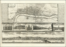
A detailed antique map of London, centered on the River Thames, engraved by Royce and published by Alexander Hogg. The map shows the city east to west in its full contemporary extent from Hyde Park to Whitechapel. Marylebone represents the furthest expansion of the city northwards, while South Bank and the rest of Southwark are sparsely populated. Much of present day London remains as fields and open space.
This map preserves the layout of London prior to the industrial revolution and destruction during World War II. All of the monuments and landmarks of London pre-dating the 19th century seen today are present on this map. St. Paul's Cathedral, the British Museum, the Tower of London, and St. James's Square are all visible, to name but a few.
Alexander Hogg's publishing house was situated in Paternoster Row, once the center of the London publishing trade. This area was destroyed during World War II bombardment and rebuilt as Paternoster Square. Presently, this is at the heart of the City, surrounded by the London Stock Exchange, the London offices of major banking corporations and, of course, St. Paul's Cathedral.
An attractively colored antique map which represents one of the great cities of the world in its pre-modern layout.
Alexander Hogg was a publisher active in London from 1778 to 1824. He worked under the sign of the Kings Arms on Paternoster Row. He is especially known for publishing architectural and historical prints, as well as maps.
![[ London ] A New and Correct Plan of the Cities and Suburbs of London & Westminster Borough of Southwark with the Country adjacent the New Buildings Roads](https://storage.googleapis.com/raremaps/img/small/102623.jpg)