


|
||

|

|
|

|
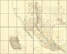
The Best Map of Texas and the American Southwest From Before 1820. Combining Pike, Humboldt, and Vancouver.
Flawless example of the first edition of Arrowsmith's landmark map of Texas, Upper California and the Southwest.
This map is perhaps the single most important 19th-century mapping of the Southwestern part of North America prior to its independence.The map is a landmark in the cartographic history of Texas and the Southwest, and a cornerstone map in American Cartographic History.
Arrowsmith's map was the first to report the discoveries of Pike and Humboldt, having been issued prior to the official accounts of these two explorers. While the map draws from the work of Humboldt extensively (and Humboldt accused Arrowsmith of plagiarism), the map shows substantial improvements over the Humboldt map in several areas.
Arrowsmith drew on several sources for the treatment of this map including:
- Vancouver's charts for his treatment of the California Coastline (including the tracks of Vancouver's voyage on the California Coast)
- Pike's accounts for the mapping of Texas, the Brazos and Guadalupe River regions and other rivers explored by Pike
- Humboldt's treatment of the Rocky Mountain regions and the Gulf Coast
Arrowsmith also shows Father Escalante's route in detail and is the first to confirm that the "Nepestle River" first reached by the Juan de Archuleta Expedition between 1664 and 1680, was in fact the Arkansas River.
The map provides an interesting snapshot of the Lower Missouri River, Kansas River and Arkansas River valleys, prior to the reports of Stephen Long and other American explorer's in the region. There are a number of annotations throughout the map providing further information on the exploration and mapping of the region. In describing the map, Martin & Martin note:
"Relying on information provided to him by the Hudson's Bay Company, [Arrowsmith] added significant details in the Northwest, and his depiction of the California coast was probably taken from the British explorer Vancouver's own charts. In the Texas area [Arrowsmith] undoubtedly used Pike's rendition of the rivers . . . while he followed Humboldt in tracing the coast from the Spanish Hydrographic Office chart . . . . By combining the best parts of Humboldt's and Pike's maps and avoiding their errors, and by adding his own new information, Arrowsmith contributed a significantly improved depiction of the region".
States of The Map
- 1810: Dated 1810. Arrowsmith identified as "Hydrographer to the Prince of Wales." Boundary of Mexico and the United States at the Mermento River in Louisiana, following the river, then running northwest to 32 degrees and more or less due westward. 1815: "Corrected to 1815." Arrowsmith identified as "Hydrographer to the Prince of Wales."
- 1816: "Corrected to 1816." Arrowsmith identified as "Hydrographer to the Prince of Wales."
- 1817: "Corrected to 1817." Arrowsmith identified as "Hydrographer to the Prince of Wales."
- 1820: Dated 1810, but Adams Onis Treaty Boundary of 1819 shown. Arrowsmith identified as "Hydrographer to his Majesty". Appears in the Atlas to Thompson's Alcedo, first published in 1825. Streeter erroneously calls this the first state, but Rumsey corrects this error.
Rarity
The map is scarce on the market.
The Arrowsmiths were a cartographic dynasty which operated from the late-eighteenth century to the mid-nineteenth. The family business was founded by Aaron Arrowsmith (1750-1823), who was renowned for carefully prepared and meticulously updated maps, globes, and charts. He created many maps that covered multiple sheets and which were massive in total size. His spare yet exacting style was recognized around the world and mapmakers from other countries, especially the young country of the United States, sought his maps and charts as exemplars for their own work.
Aaron Arrowsmith was born in County Durham in 1750. He came to London for work around 1770, where he found employment as a surveyor for the city’s mapmakers. By 1790, he had set up his own shop which specialized in general charts. Arrowsmith had five premises in his career, most of which were located on or near Soho Square, a neighborhood the led him to rub shoulders with the likes of Joseph Banks, the naturalist, and Matthew Flinders, the hydrographer.
Through his business ties and employment at the Hydrographic Office, Arrowsmith made other important relationships with Alexander Dalrymple, the Hudson’s Bay Company, and others entities. In 1810 he became Hydrographer to the Prince of Wales and, in 1820, Hydrographer to the King.
Aaron Arrowsmith died in 1823, whereby the business and title of Hydrographer to the King passed to his sons, Aaron and Samuel, and, later, his nephew, John. Aaron Jr. (1802-1854) was a founder member of the Royal Geographical Society (RGS) and left the family business in 1832; instead, he enrolled at Oxford to study to become a minister. Samuel (1805-1839) joined Aaron as a partner in the business and they traded together until Aaron left for the ministry. Samuel died at age 34 in 1839; his brother presided over his funeral. The remaining stock and copper plates were bought at auction by John Arrowsmith, their cousin.
John (1790-1873) operated his own independent business after his uncle, Aaron Arrowsmith Sr., died. After 1839, John moved into the Soho premises of his uncle and cousins. John enjoyed considerable recognition in the geography and exploration community. Like Aaron Jr., John was a founder member of the RGS and would serve as its unofficial cartographer for 43 years. Several geographical features in Australia and Canada are named after him. He carried the title Hydrographer to Queen Victoria. He died in 1873 and the majority of his stock was eventually bought by Edward Stanford, who co-founded Stanford’s map shop, which is still open in Covent Garden, London today.

![[ Denver Panorama ] Panoramic View of Over 200 Miles of the Rocky Mountain Range Distinctly Seen from Denver with the Naked Eye; also the Principal Business Portion of Denver](https://storage.googleapis.com/raremaps/img/small/88876.jpg)

![[ Pacific Northwest - Northwest Passage ] Limes Occidentis Quivira et Anian. 1597](https://storage.googleapis.com/raremaps/img/small/71207.jpg)
![[Monterey] Plan De La Baie De Monterey Situee Dans La Californie Septentrionale . . .](https://storage.googleapis.com/raremaps/img/small/99008.jpg)