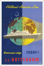
|
||

|

|
|

|
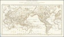
Finely engraved map of the World, surmounted by 4 smaller hemispheric projections, illustrating the routes of major explorers.
The map depicts California as an Island, the Mississippi River is shown as primarily fed by the Des Moines River, and a massive land bridge (Terra Esonis) extending from the Pacific Northwest to Japan. The coastline of Australia is beginning to take shape, although little is known about the southern and eastern coastlines. Van Diemen's Land (Tasmania) is well outlined, along with one coastline of New Zealand, as discovered by Abel Tasman. Korea is a narrow peninsula, with a massive Philippines dominating the region to the west of China and the Malay Peninsula. Russia has yet to conquer Siberia. The phantom island "Hoogland" lies off the coast of Spitsbergen, perhaps an early guess at some of the archipelagos above Russia. The Northeast Passage is clearly shown, but no polar passage above North America is evident.
The routes of the major explorers are of particular interest in this specimen. Special attention is paid to Dutch explorers. Routes to the East and West Indies abound, with rarer expeditions in search of a Northwest Passage or in search of California. Van Heemskerck's search for an Arctic passage takes a different direction, and his travels around Novaya Zemlya are included.
The map includes two smaller polar hemispheric projections, along with a model of the Solar System, based upon Ptolemy. The map contains intricate geopolitical and geomorphological detail.
![[Manuscript World Map] Weltkarte oder Europa, Asia . . .](https://storage.googleapis.com/raremaps/img/small/68619.jpg)
![[From the Library of Captain Louis Freycinet] Carte Hydrographique Des Partes Connues De La Terre Dressee sur la Projection de Mercator, Poar C.LO. Gressier , Ingenieur Hydrographe de la Marine . . . 1835 (with extensive manuscript annotations)](https://storage.googleapis.com/raremaps/img/small/58604.jpg)