![Map of Oregon Territory. By Samuel Parker. 1838. [with:] Journal of an Exploring Tour Beyond the Rocky Mountains, under the direction of the A. B. C. F. M. 1840. By Samuel Parker](https://storage.googleapis.com/raremaps/img/small/97939.jpg)


|
||

|

|
|

|
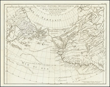
Parker's map of Oregon Territory as a landmark map in the mapping of the region. Wheat notes that the map represented a real advance, and was made from personal observation. Wagner-Camp notes that the map was the earliest to obtain any circulation which contains reliable information as to the interior of the Oregon Territory…The North Fork of the Platte is shown, with the Sweetwater flowing into it. South Pass is not named, but the sources of the Sweetwater and the Big Sandy (shown flowing into the Colorado) are close together. The Green River is a headwater of the Colorado. Bear River is shown inaccurately. Ft. Hall is shown, one of its earliest appearances. The Yellowstone River is shown, but Lewis & Clark's Biddle River is omitted. Jackson Lake is shown, feeding Henry's Fork and the Snake River. The Salmon and Clark's Fork are correctly shown, with Coeur d'Alene Indians near the lake whose waters reach the Columbia by the Spokein River, near Ft. Okanagon. Fort W(alla) W(alla) is at the mouth of the Snake. West of Salt Lake is Ogden's River, and the Clamet (Klamath), with the Umbiqua (Umpqua) to the north and the Willamette shown. North of the upper Clamet is Mt. Shasty, with Mt. McLoughlin, Mt. Vancouver and Mt. Hood. A notable achievement in the history of the mapping of the region. Wesat 438 (Illustrated) and Wagner-Camp 70. An essential map for Oregon Territory collectors. Repaired tear in upper right corner, else a nice example.

![Map of the Missouri Pacific and St. Louis, Iron Mountain and Southern Railway and Connections [Missouri Pacific Railway. St. Louis & All Points East Chair Cars Free Fast Mail Route]](https://storage.googleapis.com/raremaps/img/small/91606.jpg)
![Colton's Map of the United States The Canadas &c. Showing the Railroads, Canals, & Stage Roads With Distances From Place to Place…1856 [Pocket Map]](https://storage.googleapis.com/raremaps/img/small/85342.jpg)
![(Humboldt Atlas and Text) Geographique et Physique du Royaume de Nouvelle-Espagne [with quarto text:] Essai Politique de la Royaume de la Nouvelle-Espagne](https://storage.googleapis.com/raremaps/img/small/99796.jpg)