|
||

|

|
|

|
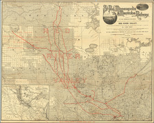
Superb and very rare official post route map of Michigan and Wisconsin from 1871.
The map shows all of Michigan and Wisconsin, with coverage to adjacent areas including Chicago, the Twin Cities, and Toledo. The map differentiates between seven kinds of mail delivery: Rail Roads; six times a week; three times a week; twice a week; once a week; Special Supply; and Mail Messenger. Nicholson's post route maps are among the most important documents for understanding the organization of people and the flows of information in 19th century America. They were updated numerous times over the years and these transitions help us understand minute changes in the human landscape. The maps are particularly useful for tracing smaller roads and paths that might not have otherwise been recorded on maps of the time.
Like all of Post Route maps of the time, the routes were updated by hand with a notice written on the map declaring "The Service on this Diagram brought up to date of June 1st 1873"
Rarity
Post Route maps are rare today, probably in part because of the meticulous and time-consuming work involved in updating them and because they were largely reserved for government officials and important members of industry who had need for information about mail delivery timing to large swathes of the country.
We can find the complete map having been offered for sale only once in the last 30+ years (presumed to be this same example).
The Michigan Historical Commission's 1921 Michigan Bibliography notes that the first edition was published in 1870. The map was updated into the 1880s.
Provenance
Lynne Garvey-Hodge, in Images of America Clifton, provides the following biography of J.H. Devereux:
John Henry Devereux (1832-1886) inherited a strong work ethic from his father, John, a "driving energy and rigid discipline--tempered by an underlying kindness and respect for his subordinates." After studying engineering and graduating from his hometown Marblehead Academy, Massachusetts, in 1848, Devereux found employment as a civil engineer at Cleveland, Columbus, and Cincinnati Railroad... His stellar reputation brought him to Washington, D.C., to serve as civil engineer of federal railroads in 1862. Daniel C. McCallum, military director of railroads, asked him to direct all transportation matters at Alexandria, Virginia--a critical location in protecting the nation's capital during the Civil War and in supporting the Union Army... Devereux outfitted railroad cards with water, heating, and lighting, allowing for better care of the war's wounded. When Devereux returned to Cleveland, his career continued to soar, as he became president of Lake Shore; Cleveland, Columbus, Cincinnati, and Indianapolis; and Atlantic and Great Western Railroads. The Cleveland Daily Leader newspaper said, "His reputation was known wherever the iron horse traveled."
![[Wisconsin Dells] Map of Kilbourn City Wisconsin](https://storage.googleapis.com/raremaps/img/small/91852.jpg)

![Milwaukee City and Environs Engraved expressly to accompany the City Directory for 1858 & 9. [with:] Milwaukee City Directory. 1858-9.](https://storage.googleapis.com/raremaps/img/small/57977.jpg)