|
||

|

|
|

|
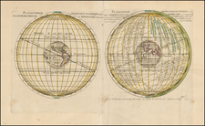
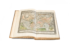
A very fine example of a double-hemisphere world map with decorative borders, first published in Romeyn de Hooghe's Les Indes Orientales et Occidentales et autres lieux, a travel guide to the East and West Indies.
The decorative borders are somewhat unusual for Dutch maps of the period. The corners show allegorical scenes depicting the four seasons: top left is Spring, with a plow and figures surveying by taking star sightings; top right is Summer, with a harvest and the accompanying wealth; bottom left is Autumn, with a battle scene; and bottom right is Winter, with people skating on a frozen river.
In the upper cusp is Ouroboros encircling a book representing the Word of God; in the lower cusp is a shadowy figure in front of a plinth piled with wealth and symbols of culture.
The map shows California as an Island. Northeast Asia and Japan are ill-formed. Australia and New Zealand are partially discovered.
Pieter van der Aa (1659-1733) was a Dutch mapmaker and publisher who printed pirated editions of foreign bestsellers and illustrated books, but is best known for his voluminous output of maps and atlases. Van der Aa was born to a German stonecutter from Holstein. Interestingly, all three van der Aa sons came to be involved in the printing business. Hildebrand was a copper engraver and Boudewyn was a printer.
![[Volcanos and the Subterranean World] Tabula Geographico-Hydrographica Motus Oceani, Currentes, Abyssos, Montes Igniuomos In Universo Orbe Indicans, Notat Haec Fig. Abyssos Montes Vulcanios](https://storage.googleapis.com/raremaps/img/small/95720.jpg)