


|
||

|

|
|

|
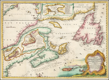
Detailed antique map of the Northeastern United, published by Rogers & Johnston.
This northeastern map shows the various counties in outline color and names towns, rivers, lakes, islands, railroads, etc.
One of the rarest of all U.S. atlases is the Rogers & Johnston Atlas of the United States &c. Conceived as a collaborative effort between W & AK Johnston (of London) and H.D. Rogers (of Boston), the project began with a wonderful wall map of the United States in 1856, which Rumsey describes as one of the most beautiful maps of the period. Unfortunately, neither the wall map nor the subsequently produced atlas achieved wide commercial success, despite its fine detail and engraving style. Complete examples of the Atlas are rare on the market.
Rogers & Johnston maps are an essential part of a comprehensive mid 19th Century American map collection, representing the only attempt by the British at a comprehensive treatment of the US in atlas format.
![(Ecclesiastical Districts of the American Northeast) Tav. CXXVIII Provincia ecclesiastica di Nuova York [e di Boston]](https://storage.googleapis.com/raremaps/img/small/89777.jpg)

![Map of the States of Massachusetts, Connecticut and Rhode Island [Large Boston Inset]](https://storage.googleapis.com/raremaps/img/small/91825.jpg)

![[ English Plantations in North America ] A New Map of the most Considerable Plantations of the English In America Dedicated to His Highness William Duke of Glocester.](https://storage.googleapis.com/raremaps/img/small/98233.jpg)