|
||

|

|
|

|
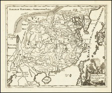
Rare large format map of Imperial Russia, extending from the Baltic and the Black Sea to China, prepared by Nicolas De Fer.
De Fer's map is based upon the reports of Nicholas Witsen, Evart Esbrand (Evert Ysbrandzoon Ides) and Philippe Avril. Adam Brand and Ysbrandzoon's route from Moscow to Bejing is shown, with a table on the right, tracking the journey of Adam Brand from 1692 to 1694.
Philippe Avril explored the overland routes to Beijing on behalf of the Society of Jesus. In 1692, he published an important description of the routes used by the Russians, along with a map of northern Asia. While Avril incorporates information from Marco Polo, Johann Grueber, Bento de Goes and Verbiest, much of his information comes from Russian sources, although Avril himself went no further east than Moscow.
Evert Ysbrandzoon Ides provided two accounts of his embassies to meet with the Emperor of China on behalf of the Czar, including one in German by Adam Brand, in 1698, and his own account in 1704. Nicolaas Witsen's Noord en Oost Tartarye, was published in Amsterdam in 1692. Witsen incorporated information received from a number of interviews with travelers returning from Tartary and through his correspondence.
Rarity
The map is quite scarce on the market.
Nicholas de Fer (1646-1720) was the son of a map seller, Antoine de Fer, and grew to be one of the most well-known mapmakers in France in the seventeenth century. He was apprenticed at twelve years old to Louis Spirinx, an engraver. When his father died in 1673, Nicholas helped his mother run the business until 1687, when he became the sole proprietor.
His earliest known work is a map of the Canal of Languedoc in 1669, while some of his earliest engravings are in the revised edition of Methode pour Apprendre Facilement la Geographie (1685). In 1697, he published his first world atlas. Perhaps his most famous map is his wall map of America, published in 1698, with its celebrated beaver scene (engraved by Hendrick van Loon, designed by Nicolas Guerard). After his death in 1720, the business passed to his sons-in-law, Guillaume Danet and Jacques-Francois Benard.