|
||

|

|
|

|
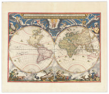
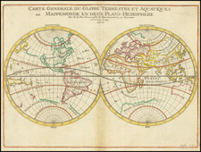
Rare French World map, first published in Paris by Melchior Tavernier in 1630.
The map is based on Hondius' World map of 1617 or possibly Honervogt's map of 1625, with one noteworth change. The ecliptic curves on Tavernier's map are reversed so that the line is north of the equator in the western hemisphere and east of south of the equator in the eastern hemisphere.
The map was the first to show Le Maire's Straits and the islands in the Pacific discovered by Le Maire and his explorations in New Guines. Hondius' map was also one of the earliest to show Hudson's Bay and the full course of the St. Lawrence in a curious configuration.
The present example is the second state of the map, bearing a date of 1636, but otherwise unchanged.
Rarity
The map is extremely rare. We note only a single example at auction or in a dealer catalog in the past 40 years (Reiss & Sohn, Auction 133, October 2009, Lot 3179).
Melchior Tavernier was a member of a large family involved in the publishing trade in Paris in the early years of the seventeenth century. Early in his career, he apparently collaborated with Henricus Hondius, as at least one of his early maps references Tavernier as the seller of a map engraved in Amsterdam, by Hondius. He is probably best known for his publication of a map of the Post Roads of France, which was copied many times until the end of the century. He also issued an atlas under the same title as J. le Clerc's Theatre Geographique, using many of Le Clerc's maps, but incorporating others from different sources. He published composite atlases and also published works for other cartographers, including N. Sanson, N. Tassin, and P. Bertius. He is not to be confused with his nephew of the same name (1594-1665), who also engraved maps for Nicolas Sanson.
![[Early Photographic Facsimile of the 1529 Ribero World Map]](https://storage.googleapis.com/raremaps/img/small/67279.jpg)