|
||

|

|
|

|
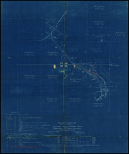
Fine early promotional map for the Phoenix, Tempe, Mesa Arizona Territory area at a very early moment in its development history.
The map was almost certainly created in about 1890, at a time when the grand reservoir and dam projects north of Phoenix were in planning mode.
The map focuses on the irrigation canals and ditches in the region, spread out across a grid of townships.
Several named roads are located, along with a "Proposed R.R."
The map is drawn by C.J. Dyer, Draughtsman. Dyer was responsible for the two great views of Phoenix published in about 1885. He also created a large view of Prescott in 1884. In 1890, Dyer ran advertisements for his mapmaking skills in several Arizona Territorial newspapers, noting:
MAPS
If you want a map made of your mine tgo to Dyer for it. If you want a map of any of the canals go to Dyer for it. If you want a sketch of your ranch or other property go to Dyer for it. If you wish gto illustrate a patent right go to Dyer for it. All work done at reasonable rates.
Office at residence, near corner of Van Buren and Center streets. Phoenix, Ariz.
Ward would go on to a successful career in local politics and ultimately became the Mayor of Phoenix for a brief period in 1899.
Rarity
OCLC locates 1 example in the Phoenix Public Library.
Rand McNally & Co. is a large American map and navigation company best known for its annual atlases. The company got its start in 1856, when William Rand opened a print shop in Chicago. He was joined in 1858 by a new employee, Andrew McNally. Together, the men established their namesake company in 1868. Originally, the company was intended to print the tickets and timetables for the trains running to and through Chicago; their first railway guide was published in 1869.
By 1870, they had shifted from just printing to publishing directories, travel guides, and newspapers. Their first map appeared in 1872 in a railway guide. The map was produced using a new wax engraving method, a cheaper process that gave the company an edge.
By 1880 Rand McNally had entered the education market with globes, wall maps, and geography texts for students. In 1923, Rand McNally published the first Goode’s World Atlas, named after its editor, Dr. J. Paul Goode. For generations afterward, this would be the standard classroom atlas.
In 1899, William Rand left the company, but McNally and his family remained, controlling the company for over a century. In 1904, they published their first road map intended for automobiles and by 1907 were publishing Photo-Auto Guides, which combined photography and mapping to help drivers. In 1924, they produced the Auto Chum, a precursor to their famous road atlases. Rand McNally would remain the leader in road maps and atlases throughout the twentieth century.
In 1937, Rand McNally opened its first store in New York City. Ever on the frontier of technology, Rand McNally pioneered the scribing process for printing tickets in 1958 and printed their first full-color road atlas in 1960. Arthur Robinson developed his now-famous projection of Rand McNally in 1969. By the 1980s, the company was exploring digital reproduction and digital databases of maps for truckers. In the 1990s, they lead the charge to develop trip-planning software and websites. Today, most of its products are available online or in a digital format, including maps for tablets and phones.
C.J. Dyer took the overland route from Jackson, Michigan, to San Francisco in 1877. Within three years he was in Napa, working as a viewmaker. By 1884, he was in Arizona, where he remained at least until 1899, and possibly later.
According to Reps, Views and Viewmakers of Urban America, Dyer was responsible for the following bird's eye views:
1880 ca. C.J. Dyer. Birdseye View of Napa City California. Looking West. Published by David L. Haas, Bookseller, Stationer & Lithographer, Napa, Cala. (Reps 161)
Five years before these views appeared, Dyer produced a lithograph of Napa, California, and it is possible that he gained his experience in that state working for a more mature artist. He also drew another print showing Novato Rancho in California. No other work of his of this type is known except for a later view of Phoenix showing the city in 1890. Dyer's name is to be found on a map of irrigated land in Arizona, but no biographical information about him has yet come to light.
The Napa Valley Register mentions that Dyer is producing a view of the city in the August 3, 1880 issue.
1885. C.J. Dyer. Bird's Eye View of Phoenix, Maricopa Co., Arizona. View Looking North-East. Lithographed by W. Byrnes. Printed by Schmidt Label & Litho Co. Print. S.F. (Reps 20)
1885 ca. C.J. Dyer. Bird's-Eye View of Prescott, A.T. Looking North East. (Reps 22)
Dyer gave his Prescott view a more conventional rectangular format, using the corners for vignettes and a legend. He placed three other vignettes above the title as insets and rather awkwardly hung two sets of vignettes below the heavy ruled border on either side of the title. The printer -- probably from the Schmidt firm -- used inks of slightly more subdued colors than those chosen for the Phoenix lithograph. (Reps, page 173)
1890. C.J. Dyer. Phoenix Arizona in the Salt River Valley. View looking northeast. Schmidt, L. & L. S.F., Cal.
We can add another bird's eye view not recorded in Reps' work:
1888. C. J. Dyer. Tempe, Maricopa Co. Arizona. Looking North East.
In 1890, Dyer was advertising his new view of Phoenix in the Arizona Republic:
A Beautiful Picture. | The New | Bird's-Eye Picture of Phoenix | Is 40 inches long and 30 inches wide, is | Lithographed in Several Colors | And shows every house in Phoenix, from the Capital Addition to the West | to the Territorial Asylum on the East. | All the Streets Are Numbered | All the additions are shown; also the | Salt River Valley, Grand, Maricopa, | ....and Arizona Canals... | Can Be Sent to Any Part of the United States | Or Europe by Mail. Price, $2.00 | ....Can be procured of.... | C.J. DYER Phoenix
In the same issue of the Arizona Republic, Dyer was advertising his services as a mapmaker:
MAPS | If you want a map made of your mine go to | Dyer for it. If you want a map of any of the | canals go to Dyer for it. If you want a sketch | of your ranch or other property go to Dyer for | it. If you wish to illustrate a patent right go to | Dyer for it. All work done at reasonable rates. | Office at residence, near corner of Van Buren | and Center streets, Phoenix, Ariz. C.J. Dyer.
In 1899 C.J. Dyer was Councilman for the First Ward of Phoenix.
Some sources have his dates as 1846-1903.

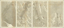
![Northeastern Arizona / Southern Utah / Northwestern New Mexico] Hopi Reservation / Navajo Reservation]](https://storage.googleapis.com/raremaps/img/small/72197dd.jpg)