|
||

|

|
|

|
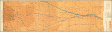
Important early map of the region between the Yellowstone and Missouri Rivers, based upon the explorations of Captain W.F. Raynolds and Lieutenant H.F. Maynadier in 1589 and 1860.
Raynolds' expedition explored the mountain ranges and upper tributaries of the Yellowstone River and the Gallatin and Madison forks of the Missouri, including the area which in 1872 was designated Yellowstone National Park, the world's first such national park. Raynolds travelled from St. Louis up the Missouri to Fort Pierre (South Dakota), then on to the Yellowstone River. Turning south from the Yellowstone, the expedition traversed the eastern edge of the Big Horn Mountains to Deer Creek near the North Platte River, where they remained for the winter. In the spring, Raynolds' party continued its explorations in the region, including a failed attempt to explore the Wind River Mountains, led by the legendary trapper Jim Bridger.
The map shows Raynolds' routes along the Yellowstone and Missouri Rivers and their tributaries, with dates and numbers along the routes likely indicating camp locations. The map places particular emphasis on topography and hydrology, but also shows roads, landmarks, settlements, and military posts. Among these are Forts Reno, Phil Kearny and Smith, significant in the Sioux War. It also includes post-1860 developments such as Ft. Casper and Camp Marshall on the upper North Platte, as well as several new forts and emigrant roads. Note the lack of detail in the area of present-day Yellowstone Park, which as mentioned above Raynolds never visited due to his inability to traverse the Wind River range.
In describing the map, Wheat states that "It is an extremely well drawn map, and except for the fact that it contains certain information gathered between the time of its making and that of its actual printing, which was not until 1868, it is probably the best map of its area that had been produced."
Contrary to Wheat's description, the map was actually prepared by 1867, as both Yale and the Montana State Library hold dissected and mounted examples bearing manuscript inscriptions from that year. Wheat knew only a slightly later state of the map with an altered imprint, issued in the Topographical Engineers' 1868 Report on the Exploration of the Yellowstone River, by Bvt. Brig. Gen. W.F. Raynolds. This later state has the notation changed to "To accompany a Report to the Bureau of Topographic Engineers / 1867."
Raynolds' map reappeared in a number of formats. For example, William E. Merrill of the Topographical Engineers distributed copies of this map in 1867, 1868 and 1869, as a template for allowing various military commanders and expedition leaders to supply manuscript additions from the field. A richly-colored later variant edition appeared in Haydens' 1869 Geological Report of the Exploration of the Yellowstone and Missouri Rivers.
A nice example of this seminal map.