|
||

|

|
|

|
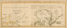
Fine, Illustrated North Polar Globe Calotte
Polar calotte that depicts coastlines and islands in far northern waters, as well as noting significant Arctic expeditions from the sixteenth and seventeenth centuries.
The calotte—a cap that covers the join of gores on a globe—includes the area from seventy degrees north to the pole. There is no land shown at the pole itself; rather, it is attractively criss-crossed with numerous rhumb lines.
There is also little land between Baffin Bay, Nova Dania--named by Jens Munk in 1619--and the area north of eastern Russia, reflecting the findings of voyages to ca. 1680. The latest expedition cited here is that of John Wood near Nova Zembla in 1676.
Spitsbergen is prominently detailed and surrounded by scenes of whaling and sealing. Polar bears range near mountains of ice, and narwhals swim the frigid seas. However, as a note in the far east states, much of the information about the local lands and peoples remains conjecturis, or conjectural.
Arctic exploration to the seventeenth century
A variety of expeditions are noted on this calotte, representing European desires to sail shorter distances to reach Asia and other markets. However, to the date this map was made, the Arctic ices were still too dense and southerly to allow ships through.
The earliest date is 1586, in reference to the Davis Strait. John Davis (ca. 1550-1605), half-brother of Sir Walter Raleigh, led three voyages to the far north (1585, 1586, 1587), specifically to Greenland, Baffin Bay, and Labrador, in pursuit of the Northwest Passage. He was the second Englishman to search for the Passage, with the first being Martin Frobisher.
Another important date is 1596, near Spitsbergen. The archipelago was first sighted by William Barentsz (ca. 1550-1598), Dutch map maker and navigator. Barentsz led three Arctic expeditions in search of the Northeast Passage in the 1590s; he died on the third attempt. By the early seventeenth century, the islands were a major base for whaling operations, as illustrated on this calotte.
Baffin Bay was named for William Baffin (ca. 1584-1622) and dated here to 1622. Baffin’s voyages were also in search of the Northwest Passage. He had served in the Muscovy Company in the early 1610s before entering into employ with the Company of Merchants of London in 1615. As a pilot, he sailed 300 miles farther north than Davis; his northernmost mark was not surpassed until 1852. He died in 1622, which may explain the date included here.
Terre de Jelmer was encountered by Cornelys Jelmerson in 1664, while the most recent voyage referenced here, that of Wood, dates to 1676. Wood had previously sailed through the Straits of Magellan in 1669. He then set his sights on the north, attracted (as were so many) by the lure of a Northeast Passage, sailing near Nova Zembla.
![[ Antarctic Regions - Shackleton ] British Antarctic Expedition 1907 -- General Map showing the Explorations and Surveys of the Expedition 1907-1909](https://storage.googleapis.com/raremaps/img/small/99613.jpg)
![Navigatio ac Itinerarium Iohannis Hugonis Linscotani in Orientalem Sive Lusitanorum Indiam... [Voyage and Journey of Jan Huygen van Linschoten to the Eastern, or Portuguese India...]](https://storage.googleapis.com/raremaps/img/small/93009.jpg)