|
||

|

|
|

|
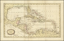
Scarce map of the Florida, the Gulf Coast, Texas, Central America and the Caribbean. The map shows the outline of the Gulf Coast based upon the most recent surveys of the Dirreccion Hydrographica (Spain) and Depot de la Marine (France). A number of settlements are shown in Texas, including san Antonio, Guardia, la Trinidad, Camp d'Axiles (abandoned French Utopian Colony) and others. Nice detail in Florida and outstanding detail throughout Central America. Minor foxing at the fold, but otherwise nice example.
Ambroise Tardieu was an important French cartographer and engraver.
He produced a number of excellent large format maps, including a revised edition of Aaron Arrowsmith's 4-sheet map of the United States. T
Tardieu came from a family boasting a number of fine engravers, and was trained from an early age by his uncle, Pierre Alexandre Tardieu (1756–1844), a leading French engraver. Showing considerable talent in this field, Ambroise persevered and became a celebrated engraver of portraits. In addition he was appointed as geographical engraver for the French government, for which he received a small stipend. In order to eke out this meagre wage, he began to trade in prints, books and maps. He is remembered for more than 800 portraits engraved through his career, many depicting scientists of the period.
Tardieu published a number of atlases, one of which appeared in 1842 and was titled Atlas universel de geographie, ancienne et moderne/dresse par Ambroise Tardieu pour l'intelligence de la Geographie universelle par Malte-Brun.


![Karte von Tejas und den angrenzenden Theilen Mejicos . . . [with California Gold Regions Inset]](https://storage.googleapis.com/raremaps/img/small/61669.jpg)
![Carte Reduite des Isles Antilles Dressee au Depost des Cartes et Plans de la Marine… [Large Inset of Virgin Islands]](https://storage.googleapis.com/raremaps/img/small/68206.jpg)