


|
||

|

|
|

|
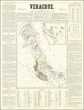
Promoting Copper Mine Investments in Sonora During the Copper Boom in the Early 20th Century
Finely executed map showing the transit routes to the Copper Mines of Eastern Sonora in Mexico.
While the map is unrecorded, it was likely published in order to promote the Cieneguita Copper Company, an American mining company active in the region at the beginning of the 20th Century. The company prospectus notes that the mines were "located in four principal groups, and all situated within a radius of three miles from the central point, the Veta Madre of La Chipiona".
The map shows the region of Sonora lying south of the Arizona border and extending to Port Stilwell, the terminus point for the Kansas City, Mexico & Orient Railroad, near the town of Topolobampo, Sinaloa, Mexico, on the Gulf of California. It illustrates the location of the company's mining claims, the wagon roads in the region, topogography and major towns in the region, along with other mining districts and mining sites. The lands of the Yaqui Copper Company are also shown, as is the route of the Cananea, Yaqui River & Pacific Railway (in light blue), which would be operated by the Southern Pacific and reach the Arizona Border via Naco, Arizona.
The Cieneguita Copper Company was a short-lived enterprise, which advertised the acquisition of 264 square miles of land in the Sahuarip Mining District in Sonora, which it advertised as "historic mines extensively developed by ancient methods . . . ", with ores "developed andleft by the Ancients owing to their inability to extra values by their crude methods."
The Kansas City, Mexico & Orient Railroad was the brain child of Arthur Stilwell (founder of Port Arthur, Texas), who built the initial lines of what would become the Kansas City Southern Railroad. After losing control of the Kansas City Southern, Stilwell announced plans to build a railroad connecting Kansas City with the Pacific Ocean and organized the Kansas City, Mexico and Orient Railway. Although progress was made, financial problems and the Mexican Revolution caused this company to be forced into receivership in March 1912. Ironically, oil was discovered under its tracks and was to contribute to the fortune of its receiver William T. Kemper.
Rarity
The map is apparently unrecorded.

![(Yucatan) Indien contrebandier de l'interieur [Indian Smuggler from the Interior]](https://storage.googleapis.com/raremaps/img/small/86592.jpg)